Churchman Brook Dam
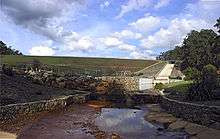
The dam wall and spillway.
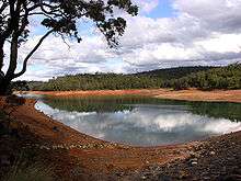
The reservoir.
Churchman Brook Dam is an earthfill embankment dam approximately 30 kilometres (20 mi) south east of Perth, Western Australia in the City of Armadale. The reservoir is a water source for Perth.
It has a capacity of 2.24 gigalitres (79 million cubic feet) for a catchment area of 16 square kilometres (6.2 sq mi).[1]
Construction of the dam commenced in 1923 and was completed in 1929; the resident engineer was Sir Russell John Dumas.[2][3][4][5][6][7]
See also
References
- ↑ Churchman Brook Dam, Watercorporation facilities brochure Archived 25 July 2008 at the Wayback Machine.Archived
- ↑ Dumas, Sir Russell John (1887 - 1975), Australian Dictionary of Biography
- ↑ "METROPOLITAN WATER SUPPLY". The West Australian. XXXIX, (6, 694). Western Australia. 7 November 1923. p. 8. Retrieved 10 May 2017 – via National Library of Australia. , ...The first section — the construction of a dam at Churchman's Brook — has been approved; operations, on the site will commence next week...
- ↑ "WATER SUPPLY.:A New Reservoir.:Work at Churchman's Brook". The West Australian. XL, (6, 842). Western Australia. 30 April 1924. p. 7. Retrieved 10 May 2017 – via National Library of Australia.
- ↑ "CHURCHMAN'S BROOK DAM: AUGMENTING THE SUMMER SUPPLY: Work being pushed aheadS". Sunday Times (Perth) (1376). Western Australia. 25 May 1924. p. 11. Retrieved 10 May 2017 – via National Library of Australia.
- ↑ "An Interesting Series of Pictures of Churchman's Brook Reservoir". Sunday Times (Perth) (1376). Western Australia. 25 May 1924. p. 11. Retrieved 10 May 2017 – via National Library of Australia.
- ↑ "CHURCHMAN'S BROOK DAM.:Heavy Cost". The West Australian. XLIV, (7, 985). Western Australia. 18 January 1928. p. 14. Retrieved 10 May 2017 – via National Library of Australia.
External links
- Churchman Brook Catchment Area Drinking Water Source Protection Plan – Integrated Water Supply System, Department of Water, Government of Western Australia, Water Resource Protection Series Report No. WRP 66.
Coordinates: 32°9′0.4″S 116°4′40.5″E / 32.150111°S 116.077917°E
This article is issued from
Wikipedia.
The text is licensed under Creative Commons - Attribution - Sharealike.
Additional terms may apply for the media files.