Choquepirhua (Arequipa)
| Choquepirhua | |
|---|---|
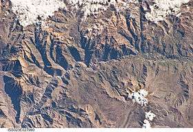 The Colca River and Choquepirhua north of it (upper left) as seen from the ISS | |
| Highest point | |
| Elevation | 5,400 m (17,700 ft) [1] |
| Coordinates | 15°25′23″S 72°10′5″W / 15.42306°S 72.16806°WCoordinates: 15°25′23″S 72°10′5″W / 15.42306°S 72.16806°W |
| Geography | |
 Choquepirhua Peru | |
| Location | Peru, Arequipa Region, Castilla Province |
| Parent range | Andes, Chila |
Choquepirhua (possibly from Aymara chuqi gold, pirwa, piwra granary,[2][3] Quechua chuqi, metal, every kind of precious metal; gold (<Aymara), pirwa deposit,[4][5] "gold granary" or "metal deposit") is a mountain in the Chila mountain range in the Andes of Peru, about 5,400 metres (17,717 ft) high. It lies in the Arequipa Region, Castilla Province, on the border of the districts of Chachas and Choco. Choquepirhua is situated south of Chila.[1]
See also
References
- 1 2 escale.minedu.gob.pe - UGEL map of the Caylloma Province 1 (Arequipa Region)
- ↑ Radio San Gabriel, "Instituto Radiofonico de Promoción Aymara" (IRPA) 1993, Republicado por Instituto de las Lenguas y Literaturas Andinas-Amazónicas (ILLLA-A) 2011, Transcripción del Vocabulario de la Lengua Aymara, P. Ludovico Bertonio 1612 (Spanish-Aymara-Aymara-Spanish dictionary)
- ↑ Ministerio de Educación, Dirección National de Educación Bilingue Intercultural, Yatiqirinaka Aru Pirwa, Lima, 2005 (Aymara-Spanish dictionary)
- ↑ Teofilo Laime Ajacopa, Diccionario Bilingüe Iskay simipi yuyayk'ancha, La Paz, 2007 (Quechua-Spanish dictionary)
- ↑ Diccionario Quechua - Español - Quechua, Academía Mayor de la Lengua Quechua, Gobierno Regional Cusco, Cusco 2005 (Quechua-Spanish dictionary) (5-vowel-system)
This article is issued from
Wikipedia.
The text is licensed under Creative Commons - Attribution - Sharealike.
Additional terms may apply for the media files.