Chestnut Street (Philadelphia)
| |
|---|---|
| Route information | |
| Maintained by City of Philadelphia | |
| Length | 5.6 mi[1] (9.0 km) |
| History | Commissioned in 1682 |
| Major junctions | |
| West end |
|
|
| |
| East end | Front Street in Penn's Landing |
| Location | |
| Counties | Philadelphia |
| Highway system | |

Chestnut Street is a major historic street in Philadelphia, Pennsylvania. It was originally named Wynne Street because Thomas Wynne's home was there. William Penn renamed it Chestnut Street in 1684. It runs east–west from the Delaware River waterfront in downtown Philadelphia through Center City and West Philadelphia. The road crosses the Schuylkill River on the Chestnut Street Bridge. It serves as eastbound Pennsylvania Route 3 between 63rd and 38th Streets.
Stratton's Tavern was located on Chestnut Street near Sixth Street. When the citizens of Philadelphia were afraid that the British might attack the essentially unmanned Fort Mifflin, the secretary of the Young Men's Democratic Society called a meeting, to be held at Stratton's Tavern on March 20, 1813. The young men agreed to volunteer their services to defend the fort.[2]
Points of interest

From east to west:
- United States Custom House (Philadelphia, Pennsylvania)
- National Liberty Museum
- Carpenters' Hall
- First National Bank (today, part of the Science History Institute)
- Old City Hall
- Second Bank of the United States
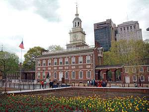
- Independence Hall
- Liberty Bell
- Ben Franklin House, formerly the Benjamin Franklin Hotel
- Belgravia Hotel
- The Coronado Building
- Drexel University
- University of Pennsylvania
Major intersections
The entire route is in Philadelphia, Philadelphia County.
| Location | mi[1] | km | Destinations | Notes | |
|---|---|---|---|---|---|
| Cobbs Creek | 0.0 | 0.0 | Western terminus of concurrency with PA 3 | ||
| University City | 2.6 | 4.2 | Eastern terminus of concurrency with PA 3 | ||
| 3.5 | 5.6 | Access via Schuylkill Avenue; exit 345 on I-76 | |||
| Schuylkill River | 3.5– 3.7 | 5.6– 6.0 | Chestnut Street Bridge | ||
| Center City | 4.5 | 7.2 | |||
| Penn's Landing | 5.6 | 9.0 | Front Street | To I-95 south | |
| 1.000 mi = 1.609 km; 1.000 km = 0.621 mi | |||||
See also
References
- 1 2 Google (July 14, 2018). "Chestnut Street" (Map). Google Maps. Google. Retrieved July 14, 2018.
- ↑ Henry, Mathew Schropp (1860). History of the Lehigh Valley: Containing a Copious Selection of the Most Interesting Facts, Traditions, Biographical Sketches, Anecdotes, Etc., Etc., Relating to Its History and Antiquities ; with Complete History of All Its Internal Improvements, Progress of the Coal and Iron Trade, Manufactures, Etc. Bixler & Corwin.