Chester, Nebraska
| Chester, Nebraska | |
|---|---|
| Village | |
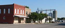 Downtown Chester | |
 Location of Chester, Nebraska | |
| Coordinates: 40°0′38″N 97°37′5″W / 40.01056°N 97.61806°WCoordinates: 40°0′38″N 97°37′5″W / 40.01056°N 97.61806°W | |
| Country | United States |
| State | Nebraska |
| County | Thayer |
| Area[1] | |
| • Total | 0.59 sq mi (1.53 km2) |
| • Land | 0.59 sq mi (1.53 km2) |
| • Water | 0 sq mi (0 km2) |
| Elevation | 1,631 ft (497 m) |
| Population (2010)[2] | |
| • Total | 232 |
| • Estimate (2016)[3] | 225 |
| • Density | 390/sq mi (150/km2) |
| Time zone | UTC-6 (Central (CST)) |
| • Summer (DST) | UTC-5 (CDT) |
| ZIP codes | 68327, 68429 |
| Area code(s) | 402 |
| FIPS code | 31-09095[4] |
| GNIS feature ID | 0828119[5] |
Chester is a village in Thayer County, Nebraska, United States. The population was 232 at the 2010 census.
Chester is notable as being the birthplace of six-man football.[6]
History
Chester was platted in 1880 when the railroad was extended to that point.[7][8] It was named for President Chester A. Arthur.[9]
Geography
Chester is located at 40°00′38″N 97°37′05″W / 40.010629°N 97.617971°W (40.010629, -97.617971).[10]
According to the United States Census Bureau, the village has a total area of 0.59 square miles (1.53 km2), all of it land.[1]
Demographics
| Historical population | |||
|---|---|---|---|
| Census | Pop. | %± | |
| 1890 | 407 | — | |
| 1900 | 439 | 7.9% | |
| 1910 | 560 | 27.6% | |
| 1920 | 529 | −5.5% | |
| 1930 | 579 | 9.5% | |
| 1940 | 634 | 9.5% | |
| 1950 | 539 | −15.0% | |
| 1960 | 480 | −10.9% | |
| 1970 | 459 | −4.4% | |
| 1980 | 435 | −5.2% | |
| 1990 | 351 | −19.3% | |
| 2000 | 294 | −16.2% | |
| 2010 | 232 | −21.1% | |
| Est. 2016 | 225 | [3] | −3.0% |
| U.S. Decennial Census[11] | |||
2010 census
As of the census[2] of 2010, there were 232 people, 111 households, and 66 families residing in the village. The population density was 393.2 inhabitants per square mile (151.8/km2). There were 150 housing units at an average density of 254.2 per square mile (98.1/km2). The racial makeup of the village was 96.6% White, 0.4% Native American, 0.9% Asian, and 2.2% from two or more races.
There were 111 households of which 18.0% had children under the age of 18 living with them, 55.9% were married couples living together, 1.8% had a female householder with no husband present, 1.8% had a male householder with no wife present, and 40.5% were non-families. 36.0% of all households were made up of individuals and 18% had someone living alone who was 65 years of age or older. The average household size was 2.09 and the average family size was 2.74.
The median age in the village was 52.6 years. 19% of residents were under the age of 18; 2.1% were between the ages of 18 and 24; 16.8% were from 25 to 44; 33.2% were from 45 to 64; and 28.9% were 65 years of age or older. The gender makeup of the village was 47.8% male and 52.2% female.
2000 census
As of the census[4] of 2000, there were 294 people, 140 households, and 83 families residing in the village. The population density was 537.7 people per square mile (206.4/km2). There were 180 housing units at an average density of 329.2 per square mile (126.4/km2). The racial makeup of the village was 98.30% White, 1.02% Native American, and 0.68% from two or more races. Hispanic or Latino of any race were 0.68% of the population.
There were 140 households out of which 20.7% had children under the age of 18 living with them, 52.1% were married couples living together, 2.1% had a female householder with no husband present, and 40.7% were non-families. 37.9% of all households were made up of individuals and 22.1% had someone living alone who was 65 years of age or older. The average household size was 2.10 and the average family size was 2.73.
In the village, the population was spread out with 19.7% under the age of 18, 4.4% from 18 to 24, 21.8% from 25 to 44, 26.5% from 45 to 64, and 27.6% who were 65 years of age or older. The median age was 48 years. For every 100 females, there were 102.8 males. For every 100 females age 18 and over, there were 96.7 males.
As of 2000 the median income for a household in the village was $21,389, and the median income for a family was $30,000. Males had a median income of $22,750 versus $17,000 for females. The per capita income for the village was $14,150. About 5.3% of families and 7.6% of the population were below the poverty line, including none of those under the age of eighteen and 15.4% of those sixty five or over.
References
- 1 2 "US Gazetteer files 2010". United States Census Bureau. Archived from the original on 2012-01-24. Retrieved 2012-06-24.
- 1 2 "American FactFinder". United States Census Bureau. Retrieved 2012-06-24.
- 1 2 "Population and Housing Unit Estimates". Retrieved June 9, 2017.
- 1 2 "American FactFinder". United States Census Bureau. Archived from the original on 2013-09-11. Retrieved 2008-01-31.
- ↑ "US Board on Geographic Names". United States Geological Survey. 2007-10-25. Retrieved 2008-01-31.
- ↑ Remembering the father of six-man football
- ↑ Burr, George L. (1921). History of Hamilton and Clay Counties, Nebraska, Volume 1. S.J. Clarke Publishing Company. p. 139.
- ↑ "Chester, Thayer County". Center for Advanced Land Management Information Technologies. University of Nebraska. Retrieved 23 August 2014.
- ↑ Exploring Nebraska Highways: Trip Trivia. Exploring America's Highway. 2007. p. 218. ISBN 978-0-9744358-7-9.
- ↑ "US Gazetteer files: 2010, 2000, and 1990". United States Census Bureau. 2011-02-12. Retrieved 2011-04-23.
- ↑ "Census of Population and Housing". Census.gov. Archived from the original on May 12, 2015. Retrieved June 4, 2015.
External links
Municipalities and communities of Thayer County, Nebraska, United States | ||
|---|---|---|
| Cities | ||
| Villages | ||
| Ghost towns | ||