Chersky Range
Coordinates: 64°44′N 142°58′E / 64.733°N 142.967°E
| Chersky Range | |
|---|---|
 | |
| Highest point | |
| Peak | Peak Pobeda |
| Elevation | 2,197 metres (7,208 ft) |
| Dimensions | |
| Length | 1,500 km (930 mi) |
| Geography | |
| Country |
|
| States/Provinces | Sakha Republic and Magadan Oblast |
| Geology | |
| Age of rock | Precambrian and Cretaceous |
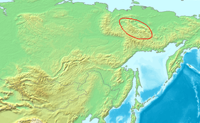
The Chersky Range is a chain of mountains in northeastern Siberia between the Yana River and the Indigirka River. It generally runs from northwest to southeast through the Sakha Republic and Magadan Oblast. The highest peak in the range is Peak Pobeda, which is 3,003 meters tall. The range lies on the boundary between the Eurasian and North American tectonic plates.[1] The Chersky mountains, along with the neighboring Verkhoyansk Range, have a moderate effect on the climate of Siberia. The ridges obstruct west-moving air flows, decreasing the amount of snowfall in the plains to the west.
At some time between 1633 and 1642 Poznik Ivanov ascended a tributary of the lower Lena, crossed the Verkhoyansk Range to the upper Yana and then crossed the Chersky Range to the Indigirka.[2] The range was sighted in 1926 by Sergei Obruchev (Vladimir Obruchev's son) and named by the Russian Geographical Society after the Polish explorer and geographer Ivan Chersky (or Jan Czerski).[3]
Tectonics
The precise nature of the boundary between the North American and Eurasian tectonic plates in the area of the Chersky Range is still not fully understood and is the subject of ongoing research. By the 1980s, the Chersky Range was considered mostly a zone of continental rifting where the crust was spreading apart.[4] However, the current view is that the Chersky Range is mostly an active suture zone, a continental convergent plate boundary, where compression is occurring as the two plates press against each other.[5] There is thought to be a point in the Chersky Range where the extensional forces coming from the north change to the compressional forces noted throughout most of the range. The Chersky Range is also thought to include a geologic triple junction where the Ulakhan Fault intersects the suture zone. Whatever the exact nature of the regional tectonics, the Chersky Range is a seismically active zone. It connects in the north with the landward extension of the Laptev Sea Rift, itself a continental extension of the Mid-Arctic Gakkel Ridge.
See also
Notes
- ↑ News Archive - The Earth Institute at Columbia University
- ↑ G. Patrick March,'Eastern Destiny:Russia in Asia and the North Pacific, 1996, chapter 3
- ↑ Obruchev, S. (1927). "Discovery of a Great Range in North-East Siberia". The Geographical Journal. 70 (5): 464–470. doi:10.2307/1783479. JSTOR 1783479.
- ↑ "Geodynamics and Late Cenozoic Evolution of the Asia/Pacific Transitional Zone", in Tectonics, International Geological Congress Staff, 27th International Geological Congress, Published 1984 by VSP
- ↑ The Physical Geography of Northern Eurasia, ed. Maria Shahgedanova, published by Oxford University Press 2003