Chatsworth, Ontario (town)
| Chatsworth | |
|---|---|
| Unincorporated village | |
 | |
| Coordinates: 44°27′13″N 80°53′45″W / 44.45361°N 80.89583°WCoordinates: 44°27′13″N 80°53′45″W / 44.45361°N 80.89583°W | |
| Country | Canada |
| Province | Ontario |
| County | Grey |
| Township | Chatsworth |
| Elevation | 296 m (971 ft) |
| Population (2001) | |
| • Total | 6,280 |
| Time zone | UTC-5 (EST) |
| • Summer (DST) | UTC-4 (EDT) |
| Postal code | N0H 1G0 |
| Area code(s) | 519 and 226 |
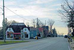
Chatsworth is a community in Grey County, Ontario, Canada, part of the Township of Chatsworth. It is located south of Owen Sound and north of Durham where Highways 6 and 10 merge. The village neighbours Williamsford, Dornoch, and Desboro.
History
Originally named Johnstown after an early landowner, the post office was renamed Holland East in 1851. It was renamed again to its present name in 1857. The name comes from Chatsworth House, in Derbyshire, near the home town of the postmaster at that time.[1]
Chatsworth was founded in 1848 at the northern terminus of the Toronto-Sydenham Colonization Road. Modern Highway 10 follows most of the original road's route. On January 1, 2001, The Village of Chatsworth was merged into the new Township of Chatsworth, along with Holland and Sullivan Townships.
Famous Canadian suffragette Nellie McClung was born in Chatsworth.
References
- ↑ Rayburn, Alan (1997). Place names of Ontario. Toronto: University of Toronto Press. p. 66. ISBN 0-8020-7207-0. Retrieved 13 October 2017.
| Wikimedia Commons has media related to Chatsworth, Ontario. |
Places adjacent to Chatsworth, Ontario (town) | ||||||||||
|---|---|---|---|---|---|---|---|---|---|---|
| ||||||||||