Charlottesville, Indiana
| Charlottesville, Indiana | |
|---|---|
| Unincorporated community | |
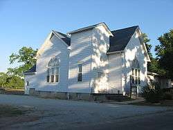 Charlottesville Friends Church | |
 Charlottesville  Charlottesville | |
| Coordinates: 39°47′25″N 85°36′46″W / 39.79028°N 85.61278°WCoordinates: 39°47′25″N 85°36′46″W / 39.79028°N 85.61278°W | |
| Country | United States |
| State | Indiana |
| Counties | Hancock, Rush |
| Townships | Jackson (H), Ripley (R) |
| Elevation[1] | 942 ft (287 m) |
| Population (2012) | |
| • Total | 631 |
| Time zone | UTC-5 (Eastern (EST)) |
| • Summer (DST) | UTC-4 (EDT) |
| ZIP code | 46117 |
| Area code(s) | 765 |
| FIPS code | 18-12196[2] |
| GNIS feature ID | 432430 |
Charlottesville is an unincorporated community in Hancock and Rush counties in the U.S. state of Indiana.[3] The Hancock County portion is in Jackson Township, while the Rush County portion is in Ripley Township.[4]
History
Charlottesville was laid out and platted in 1830.[5] The community's name most likely was a transfer from Charlottesville, Virginia.[6] It was for a time incorporated as a town, from 1867.[7]
The Charlottesville post office has been in operation since 1831.[8]
Geography
Charlottesville is located at 39°47′25″N 85°36′46″W / 39.79028°N 85.61278°W.
Transportation
Major Roads
Education
Eastern Hancock Community School Corporation services the towns of Charlottesville, Wilkinson, Shirley, Warrington, and surrounding areas in eastern Hancock County. It consists of one elementary school (Grades K - 5), one middle school (Grades 6 - 8), and one high school (Grades 9 - 12).
References
- ↑ "US Board on Geographic Names". United States Geological Survey. October 25, 2007. Retrieved 2017-02-25.
- ↑ "American FactFinder". United States Census Bureau. Archived from the original on 2013-09-11. Retrieved 2008-01-31.
- ↑ "Charlottesville, Indiana". Geographic Names Information System. United States Geological Survey. Retrieved 2009-10-10.
- ↑ Rush County: Interim Report. Indiana Historic Sites and Structures Inventory. Indianapolis: Indiana Landmarks, 1988, 20.
- ↑ Binford, John H. (1882). History of Hancock County, Indiana: From Its Earliest Settlement by the "pale Face," in 1818, Down to 1882. King & Binford. p. 245.
- ↑ Baker, Ronald L. (October 1995). From Needmore to Prosperity: Hoosier Place Names in Folklore and History. Indiana University Press. p. 92. ISBN 978-0-253-32866-3.
...probably named for Charlottesville, Virginia...
- ↑ Richman, George J. (1916). History of Hancock County, Indiana: Its People, Industries and Institutions. Wm. Mitchell Printing Company. p. 720.
- ↑ "Hancock County". Jim Forte Postal History. Retrieved February 25, 2017.
Municipalities and communities of Hancock County, Indiana, United States | ||
|---|---|---|
| City | ||
| Towns | ||
| Townships | ||
| Unincorporated communities | ||
| Footnotes | ‡This populated place also has portions in an adjacent county or counties | |
Municipalities and communities of Rush County, Indiana, United States | ||
|---|---|---|
| City | ||
| Towns | ||
| Townships | ||
| CDPs | ||
| Other unincorporated communities | ||
| Footnotes | ‡This populated place also has portions in an adjacent county or counties | |