Charles City, Virginia
| Charles City, Virginia | |
|---|---|
| Census-designated place | |
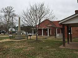 Charles City, 2017, showing the Confederate monument and the historic courthouse. | |
 Charles City Location in Virginia | |
| Coordinates: 37°20′37″N 77°4′16″W / 37.34361°N 77.07111°WCoordinates: 37°20′37″N 77°4′16″W / 37.34361°N 77.07111°W | |
| Country | United States |
| State | Virginia |
| County | Charles City |
| Area | |
| • Total | 2.7 sq mi (7.1 km2) |
| • Land | 2.7 sq mi (7.0 km2) |
| • Water | 0.04 sq mi (0.1 km2) |
| Elevation | 10 ft (3 m) |
| Population (2010) | |
| • Total | 133 |
| • Density | 49/sq mi (19.0/km2) |
| Time zone | UTC−5 (Eastern (EST)) |
| • Summer (DST) | UTC−4 (EDT) |
| ZIP code | 23030 |
| FIPS code | 51-14904 |
| GNIS feature ID | 1498561 |
Charles City is a census-designated place (CDP) in Charles City County, Virginia, United States.[1] It is the county seat of Charles City County. The population as of the 2010 census was 133.[2]
The community is centered on the Charles City County Court House, from which it takes its variant names Charles City Court House and Charles City Courthouse. Charles City lies at the intersection of State Routes 5 and 155. It is 30 miles (48 km) southeast of Richmond, 17 miles (27 km) east of Hopewell, 23 miles (37 km) west of Williamsburg, and about 2 miles (3 km) north of the James River.
Notable people
- Susan Wise Bauer, writer and historian
- Lott Cary, first black missionary to Africa
- Benjamin Harrison V, signer of the Declaration of Independence
- Martha Jefferson, First Lady of Virginia
- Freeman Walker, US senator for Georgia
- John Tyler, US president
References
- ↑ "Find a County". National Association of Counties. Archived from the original on 2011-05-31. Retrieved 2011-06-07.
- ↑ "Geographic Identifiers: 2010 Demographic Profile Data (G001): Charles City CDP, Virginia". U.S. Census Bureau, American Factfinder. Retrieved August 24, 2015.
Municipalities and communities of Charles City County, Virginia, United States | ||
|---|---|---|
| CDP | 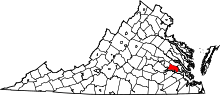 | |
| Unincorporated communities | ||
This article is issued from
Wikipedia.
The text is licensed under Creative Commons - Attribution - Sharealike.
Additional terms may apply for the media files.