Chappells, South Carolina
| Chappells, South Carolina | |
|---|---|
| Unincorporated community | |
 Chappells, South Carolina  Chappells, South Carolina | |
| Coordinates: 34°10′47″N 81°52′00″W / 34.17972°N 81.86667°WCoordinates: 34°10′47″N 81°52′00″W / 34.17972°N 81.86667°W | |
| Country | United States |
| State | South Carolina |
| County | Newberry |
| Elevation | 436 ft (133 m) |
| Time zone | UTC-5 (Eastern (EST)) |
| • Summer (DST) | UTC-4 (EDT) |
| ZIP code | 29037 |
| Area code(s) | 803 |
| GNIS feature ID | 1247255[1] |
Chappells (also Chappell, Chappells Bridge) is an unincorporated community, in Newberry County, South Carolina, United States.[1]
The Moon-Dominick House and Webb-Coleman House are listed on the National Register of Historic Places.[2]
Notes
- 1 2 "Chappells, South Carolina". Geographic Names Information System. United States Geological Survey.
- ↑ National Park Service (2010-07-09). "National Register Information System". National Register of Historic Places. National Park Service.
Municipalities and communities of Newberry County, South Carolina, United States | ||
|---|---|---|
| City | 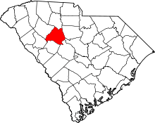 | |
| Towns | ||
| Unincorporated communities | ||
| Footnotes | ‡This populated place also has portions in an adjacent county or counties | |
This article is issued from
Wikipedia.
The text is licensed under Creative Commons - Attribution - Sharealike.
Additional terms may apply for the media files.