Chapman Peak
| Chapman Peak | |
|---|---|
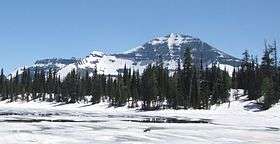 Chapman Peak from Summit Lake in July 2011 | |
| Highest point | |
| Elevation | 9,411 ft (2,868 m) [1] NAVD 88 |
| Prominence | 2,206 ft (672 m) [1] |
| Parent peak | Kintla Peak[1] |
| Coordinates | 48°57′47″N 114°01′26″W / 48.96306°N 114.02389°WCoordinates: 48°57′47″N 114°01′26″W / 48.96306°N 114.02389°W [2] |
| Geography | |
 Chapman Peak | |
| Parent range | Livingston Range |
| Topo map | USGS Mount Carter, MT |
Chapman Peak (9,411 feet (2,868 m)) is located in the Livingston Range, Glacier National Park in the U.S. state of Montana.[3] Chapman Peak is situated along the Continental Divide.
See also
References
- 1 2 3 "Chapman Peak, Montana". Peakbagger.com. Retrieved June 4, 2018.
- ↑ "Chapman Peak". Geographic Names Information System. United States Geological Survey. Retrieved June 4, 2018.
- ↑ Mount Carter, MT (Map). TopoQwest (United States Geological Survey Maps). Retrieved June 4, 2018.
This article is issued from
Wikipedia.
The text is licensed under Creative Commons - Attribution - Sharealike.
Additional terms may apply for the media files.