Chandlerville, Kentucky
| Chandlerville, Kentucky | |
|---|---|
| Unincorporated community | |
 Chandlerville  Chandlerville | |
| Coordinates: 37°56′05″N 82°48′49″W / 37.93472°N 82.81361°WCoordinates: 37°56′05″N 82°48′49″W / 37.93472°N 82.81361°W | |
| Country | United States |
| State | Kentucky |
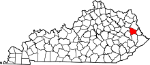
| County | Johnson |
| Elevation | 860 ft (260 m) |
| Time zone | UTC-5 (Eastern (EST)) |
| • Summer (DST) | UTC-4 (EDT) |
| ZIP codes | 41257 |
| GNIS feature ID | 507684 |
Chandlerville is an unincorporated community in Johnson County, Kentucky, United States. It is at an elevation of 860 feet (262 m).[1] Chandlerville's ZIP code is 41257.
References
- ↑ U.S. Geological Survey Geographic Names Information System: Chandlerville, Kentucky Retrieved on 2009-11-28
This article is issued from
Wikipedia.
The text is licensed under Creative Commons - Attribution - Sharealike.
Additional terms may apply for the media files.