Chamberlain USFS Airport
| Chamberlain USFS Airport | |||||||||||||||
|---|---|---|---|---|---|---|---|---|---|---|---|---|---|---|---|
 | |||||||||||||||
| Summary | |||||||||||||||
| Airport type | Public | ||||||||||||||
| Owner | U.S. Forest Service | ||||||||||||||
| Serves | Chamberlain Guard Station, Idaho | ||||||||||||||
| Elevation AMSL | 5,765 ft / 1,757 m | ||||||||||||||
| Coordinates | 45°22′45″N 115°11′48″W / 45.37917°N 115.19667°W | ||||||||||||||
| Map | |||||||||||||||
 Chamberlain USFS Airport | |||||||||||||||
| Runways | |||||||||||||||
| |||||||||||||||
| Statistics (2009) | |||||||||||||||
| |||||||||||||||
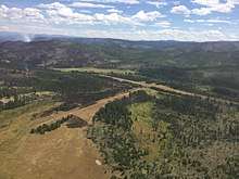
Chamberlain USFS Airport (FAA LID: U79) is a public use airport located at Chamberlain Guard Station, in Idaho County, Idaho, United States. The airport is owned by the U.S. Forest Service.[1] It is located near Chamberlain Creek[2] in the Payette National Forest.
Facilities and aircraft
Chamberlain USFS Airport covers an area of 55 acres (22 ha) at an elevation of 5,765 feet (1,757 m) above mean sea level. It has two runways: 7/25 is 4,100 by 200 feet (1,250 x 61 m) with a turf and dirt surface and 15/33 is 2,700 by 140 feet (823 x 43 m) with a turf surface. For the 12-month period ending September 24, 2009, the airport had 4,000 aircraft operations, an average of 10 per day: 62.5% general aviation and 37.5% air taxi.[1]
References
- 1 2 3 FAA Airport Master Record for U79 (Form 5010 PDF). Federal Aviation Administration. Effective 29 July 2010.
- ↑ "Chamberlain Basin USFS (U79)". Airport Facility Directory. Idaho Transportation Department. Archived from the original on 29 November 2010. Retrieved 26 September 2010.
External links
- Topo map as of 1 July 1974 from USGS The National Map
- Resources for this airport:
- FAA airport information for U79
- AirNav airport information for U79
- FlightAware airport information and live flight tracker
- SkyVector aeronautical chart for U79
| Wikimedia Commons has media related to Chamberlain USFS Airport. |
This article is issued from
Wikipedia.
The text is licensed under Creative Commons - Attribution - Sharealike.
Additional terms may apply for the media files.