Chōjagahara Site
| 長者ヶ原遺跡 | |
 Chōjagahara Site  Chōjagahara Site (Japan) | |
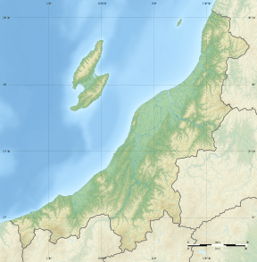
| Location | Itoigawa, Niigata, Japan |
|---|---|
| Region | Hokuriku region |
| Coordinates | 37°01′38″N 137°51′55″E / 37.02722°N 137.86528°ECoordinates: 37°01′38″N 137°51′55″E / 37.02722°N 137.86528°E |
| Altitude | 80 m (262 ft) |
| Type | Settlement |
| History | |
| Founded | Jōmon |
| Site notes | |
| Ownership | National Historic Site |
| Public access | Yes |
Chōjagahara Site (長者ヶ原遺跡 Chōjagahara Iseki) is an archaeological park containing the remnants of a middle Jōmon period settlement located in what is now part of the city of Itoigawa, Niigata in the Hokuriku region of Japan. The site was designated a National Historic Site of Japan in 1971.[1]
Overview
The site is located on a hill about 80 meters above sea level, near the Himegawa River, and contains the ruins of a large village from in the middle of the Jomon period (5,000 to 3,500 years ago), which included a production base for jadeite stone axes and jade beads. The site has been excavated three times since 1945 by a team from Keio University, but the portion of the site excavated so far is only about 3% of the complete site and 10% of the village. Jade beads made at this site have been found throughout the Hokuriku region and into the Kantō region of Japan.
The earthenware found at the site has a distinctive pattern, and is styled by archaeologists as "Chōjagahara-style pottery". However, pottery from various other regions of Japan have been found at the site, indicating widespread trade.
The site is open to the public as an archaeological park, with reconstructed pit dwellings and elevated floor buildings, and a small museum exhibiting findings from the site.
See also
References
- ↑ "長者ヶ原遺跡" [Chōjagahara Iseki] (in Japanese). Agency for Cultural Affairs.
External links
- Itoigawa City Tourist Information home page (in Japanese)