Cerro al Volturno
| Cerro al Volturno | ||
|---|---|---|
| Comune | ||
| Comune di Cerro al Volturno | ||
 | ||
| ||
 Cerro al Volturno Location of Cerro al Volturno in Italy | ||
| Coordinates: 41°39′N 14°8′E / 41.650°N 14.133°E | ||
| Country | Italy | |
| Region | Molise | |
| Province | Isernia (IS) | |
| Government | ||
| • Mayor | Remo Di Ianni | |
| Area | ||
| • Total | 23.79 km2 (9.19 sq mi) | |
| Elevation | 572 m (1,877 ft) | |
| Population (1 January 2016)[1] | ||
| • Total | 1,281 | |
| • Density | 54/km2 (140/sq mi) | |
| Demonym(s) | Cerresi | |
| Time zone | UTC+1 (CET) | |
| • Summer (DST) | UTC+2 (CEST) | |
| Postal code | 86072 | |
| Dialing code | 0865 | |
| Website | Official website | |

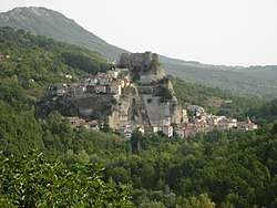
Cerro al Volturno is a comune (municipality) in the Province of Isernia in the Italian region Molise, located about 45 kilometres (28 mi) west of Campobasso and about 10 kilometres (6 mi) northwest of Isernia.
The town was founded in the ancient times by the Samnites (3rd century BC). It houses a castle called Pandone, built around 1000 on a spur commanding the nearby valley.
References

This article is issued from
Wikipedia.
The text is licensed under Creative Commons - Attribution - Sharealike.
Additional terms may apply for the media files.