Castelpizzuto
| Castelpizzuto | |
|---|---|
| Comune | |
| Comune di Castelpizzuto | |
 Castelpizzuto Location of Castelpizzuto in Italy | |
| Coordinates: 41°31′N 14°18′E / 41.517°N 14.300°ECoordinates: 41°31′N 14°18′E / 41.517°N 14.300°E | |
| Country | Italy |
| Region | Molise |
| Province | Province of Isernia (IS) |
| Area | |
| • Total | 15.2 km2 (5.9 sq mi) |
| Population (Dec. 2004) | |
| • Total | 156 |
| • Density | 10/km2 (27/sq mi) |
| Time zone | UTC+1 (CET) |
| • Summer (DST) | UTC+2 (CEST) |
| Postal code | 86090 |
| Dialing code | 0865 |
Castelpizzuto is a comune (municipality) in the Province of Isernia in the Italian region Molise, located about 30 kilometres (19 mi) west of Campobasso and about 11 kilometres (7 mi) southeast of Isernia. As of 31 December 2004, it had a population of 156 and an area of 15.2 square kilometres (5.9 sq mi).[1]
Castelpizzuto borders the following municipalities: Castelpetroso, Longano, Pettoranello del Molise, Roccamandolfi, Santa Maria del Molise.
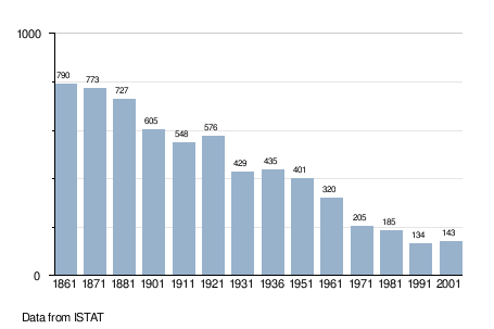
Demographic evolution
References

This article is issued from
Wikipedia.
The text is licensed under Creative Commons - Attribution - Sharealike.
Additional terms may apply for the media files.