Cerro Corá, Rio Grande do Norte
| Cerro Corá | ||
|---|---|---|
| Municipality | ||
| ||
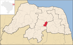 Location in Rio Grande do Norte state | ||
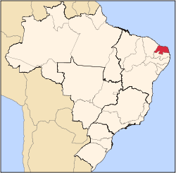
 Cerro Corá Location in Brazil | ||
| Coordinates: 6°02′45″S 36°20′45″W / 6.04583°S 36.34583°WCoordinates: 6°02′45″S 36°20′45″W / 6.04583°S 36.34583°W | ||
| Country |
| |
| Region | Northeast Region | |
| State | Rio Grande do Norte | |
| Area | ||
| • Total | 394 km2 (152 sq mi) | |
| Population (2003) | ||
| • Total | 10,935 | |
| • Density | 28/km2 (72/sq mi) | |
| Time zone | BRT (UTC-3) | |

Cerro Corá is a municipality (município) in the Brazilian state of Rio Grande do Norte. In the 2003 IBGE, it reported an estimated population of 10,935 inhabitants. The municipality covers a total area of 394 km².
References
Capital: Natal | |||||||||||||||
| Mesoregion Agreste Potiguar |
|  | |||||||||||||
| Mesoregion Central Potiguar |
| ||||||||||||||
| Mesoregion Leste Potiguar |
| ||||||||||||||
| Mesoregion Oeste Potiguar |
| ||||||||||||||
This article is issued from
Wikipedia.
The text is licensed under Creative Commons - Attribution - Sharealike.
Additional terms may apply for the media files.