Cerro Bonete
| Cerro Bonete | |
|---|---|
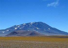 Bonete from the south. | |
| Highest point | |
| Elevation | 6,759 m (22,175 ft) |
| Coordinates | 28°01′07″S 68°45′22″W / 28.0187°S 68.7561°WCoordinates: 28°01′07″S 68°45′22″W / 28.0187°S 68.7561°W[1] |
| Geography | |
| Location | La Rioja, Argentina |
| Parent range | Andes |
Cerro Bonete is a mountain in the north of the province of La Rioja, Argentina, near the provincial border with Catamarca. Its summit is 6,759 m above mean sea level, making it the fifth-highest separate mountain in the Americas (after Aconcagua, Ojos del Salado, Monte Pissis, and Huascaran). SRTM data disproves the frequently-made claim that its summit is 6,872 m above sea level.
Within the last 3.5 million years, volcanic activity at Cerro Bonete has formed lava domes of dacite and rhyodacite.[2]
See also
External links
- (in English) Cerro Bonete on summitpost
- (in Spanish) Cordillera de los Andes
References
- ↑ Cerro Bonete on Google Maps
- ↑ Mpodozis, C.; Kay, S. M. (2009). Evolution of < 10 Ma Valle Ancho Region Lavas, Southern End of the Central Andean Volcanic Zone (~27.5°S) (PDF). XII Congreso Geológico Chileno. Santiago. pp. 2–3. Retrieved 24 March 2017.
This article is issued from
Wikipedia.
The text is licensed under Creative Commons - Attribution - Sharealike.
Additional terms may apply for the media files.