Central Station Metro station
| Central Station | |
|---|---|
| Tyne & Wear Metro | |
|
| |
 | |
| Location | |
| Place | Newcastle City Centre |
| Local authority | Newcastle |
| Fare zone information | |
| Network One zone | 1 |
| Metro zone | A |
| Original (1979) zone | 26 |
| Station code | CEN |
| Usage | |
| Metro Usage | 2.53[1] million |
| History | |
| Opened | 15 November 1981 |
| List of stations | |
| Railways between Newcastle and Gateshead |
|---|
Central Station often referred to as Central is an underground station on the Tyne and Wear Metro in Newcastle upon Tyne, England. It is located below Newcastle railway station, from which the Metro station gets its name. The station is the third-busiest on the network after Monument and Haymarket.[2]
The station has both entrances from inside the railway station for passengers transferring to or from National Rail services, and entrances from the street outside to allow easy access and egress for passengers not using the rail system.
The underground station opened in 1981, Metro services from this station replaced some routes that had formerly been operated from the mainline station towards Benton and Tynemouth via the North Tyneside Loop. In 1984 Metro reached South Shields Metro station replacing British Rail train services to South Shields. In 2002 Metro commenced services to Sunderland and South Hylton, sharing tracks with Northern services on the Durham Coast Line between Pelaw and Sunderland.
Station refurbishment
A £6m revamp of Central Station metro began in September 2015, with the station being closed from 8pm, Sundays to Thursdays, reopening each morning as usual. The work was complete by late 2016. A estimated 600,000 people used the station on the first day after refurbishment.[3]
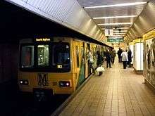
Gallery
.JPG) Entrance from inside the railway station
Entrance from inside the railway station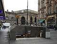 Exterior entrance
.JPG) Concourse
Concourse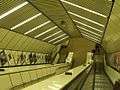 Escalators
References
- ↑ "Automated Announcements / Track Map / Usage Statistics". 2015–2016. Retrieved 29 April 2017.
- ↑ "Automated Announcements / Track Map / Usage Statistics". 2015–2016. Retrieved 29 April 2017.
- ↑ "Nexus". Nexus. Retrieved 2015-09-15.
External links
| Wikimedia Commons has media related to Central Station Metro station. |
- Train times and station information for Central Station Metro station from Nexus
| Preceding station | Tyne and Wear Metro | Following station | ||
|---|---|---|---|---|
towards St James via the Coast | Yellow line | towards South Shields |
||
towards Airport | Green line | towards South Hylton |
| Operations |
| ||||||
|---|---|---|---|---|---|---|---|
| Stations |
| ||||||
| Related topics |
| ||||||