Central Elgin
| Central Elgin | |
|---|---|
| Municipality (lower-tier) | |
| Municipality of Central Elgin | |
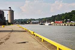 Harbourfront at Port Stanley | |
 Central Elgin Location in southern Ontario | |
| Coordinates: 42°46′N 81°06′W / 42.767°N 81.100°WCoordinates: 42°46′N 81°06′W / 42.767°N 81.100°W | |
| Country |
|
| Province |
|
| County | Elgin |
| Settled | 1822 |
| Formed | 1998 |
| Government | |
| • Mayor | David Marr |
| • Federal riding | Elgin—Middlesex—London |
| • Prov. riding | Elgin—Middlesex—London |
| Area[1] | |
| • Land | 280.23 km2 (108.20 sq mi) |
| Population (2011)[1] | |
| • Total | 12,743 |
| • Density | 45.5/km2 (118/sq mi) |
| Time zone | UTC-5 (EST) |
| • Summer (DST) | UTC-4 (EDT) |
| Postal code span | N0L, N5L |
| Area code(s) | 519 and 226 |
| Website |
www |
Central Elgin is a township in southwestern Ontario, Canada in Elgin County on Lake Erie. It was formed in 1998 through the amalgamation of the Township of Yarmouth with the Villages of Belmont and Port Stanley. It is part of the London census metropolitan area.
Communities
The municipality includes the population centres Port Stanley and Belmont. Other communities include Dexter, Lawton's Corners, Lyndale, Lynhurst, Mapleton, New Sarum, Norman, Sparta, Union, Whites and Yarmouth Centre.
Mayors
- Bill Walters, -1999
- David M. Rock, 1999–2006
- Born June 16, 1948 in St. Thomas, Ontario. He was also chair of the Elgin Group Police Services Board.[2] While he was mayor, there were discussions about proposed new ferry services on Lake Erie and their financial implications.[3]
- Sylvia Hofhuis, 2006–2010
- Tom Marks, 2010
- Bill Walters 2010–2014
- David Marr 2014–
Demographics
| Canada census – Central Elgin community profile | |||
|---|---|---|---|
| 2011 | 2006 | ||
| Population: | 12,743 (0.2% from 2006) | 12,723 (3.5% from 2001) | |
| Land area: | 280.23 km2 (108.20 sq mi) | 280.22 km2 (108.19 sq mi) | |
| Population density: | 45.5/km2 (118/sq mi) | 45.4/km2 (118/sq mi) | |
| Median age: | 44.9 (M: 44.7, F: 45.1) | 42.5 (M: 42.5, F: 42.6) | |
| Total private dwellings: | 5174 | 5115 | |
| Median household income: | $71,300 | ||
| References: 2011[4] 2006[5] earlier[6] | |||
Population trend:[7]
- Population in 2006: 12,773
- Population in 2001: 12,360 (or 12,293 when adjusted to 2006 boundaries)
- Population total in 1996: 12,156
- Belmont (village): 1632
- Port Stanley (village): 2499
- Yarmouth (township): 7148
- Population in 1991:
- Belmont (village): 1404
- Port Stanley (village): 2223
- Yarmouth (township): 7820
See also
References
- 1 2 "Central Elgin census profile". 2011 Census of Population. Statistics Canada. Retrieved 2012-08-09.
- ↑ Township of Southwold - Council Meeting Agenda, March 21, 2005
- ↑ "Ferry proposals hinge on funding - Port Stanley Burwell’s closest competitor" Archived June 6, 2007, at the Wayback Machine., The Tillsonburg News, January 20, 2006
- ↑ "2011 Community Profiles". Canada 2011 Census. Statistics Canada. July 5, 2013. Retrieved 2012-08-09.
- ↑ "2006 Community Profiles". Canada 2006 Census. Statistics Canada. March 30, 2011. Retrieved 2011-02-11.
- ↑ "2001 Community Profiles". Canada 2001 Census. Statistics Canada. February 17, 2012.
- ↑ Statistics Canada: 1996, 2001, 2006 census
External links
| Wikimedia Commons has media related to Central Elgin. |
Places adjacent to Central Elgin | ||||||||||
|---|---|---|---|---|---|---|---|---|---|---|
| ||||||||||
This article is issued from
Wikipedia.
The text is licensed under Creative Commons - Attribution - Sharealike.
Additional terms may apply for the media files.