Central Darling Shire
| Central Darling Shire New South Wales | |||||||||||||||
|---|---|---|---|---|---|---|---|---|---|---|---|---|---|---|---|
.jpg) Shire Office Complex, Wilcannia | |||||||||||||||
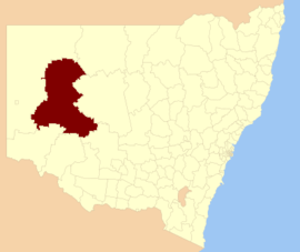 Location in New South Wales | |||||||||||||||
| Coordinates | 31°34′S 143°22′E / 31.567°S 143.367°ECoordinates: 31°34′S 143°22′E / 31.567°S 143.367°E | ||||||||||||||
| Population | 1,833 (2016 census)[1] | ||||||||||||||
| • Density | 0.034255/km2 (0.088719/sq mi) | ||||||||||||||
| Established | 20 March 1959[2][3] | ||||||||||||||
| Area | 53,511 km2 (20,660.7 sq mi) | ||||||||||||||
| Mayor | Raymond Longfellow (Unaligned) | ||||||||||||||
| Council seat | Wilcannia | ||||||||||||||
| Region | Far West | ||||||||||||||
| State electorate(s) | Barwon | ||||||||||||||
| Federal Division(s) | Parkes[4] | ||||||||||||||
 | |||||||||||||||
| Website | Central Darling Shire | ||||||||||||||
| |||||||||||||||
Central Darling Shire is a local government area in the Far West region of New South Wales, Australia. The Shire is located adjacent to the Barrier Highway. Central Darling Shire was constituted in 1959 and at 53,511 square kilometres (20,661 sq mi), it is the largest incorporated local government area in New South Wales.
The Mayor of Central Darling Shire Council is Cr. Ray Longfellow, who is unaligned with any political party.
Main towns/villages
The Shire includes the towns of Ivanhoe, Menindee, Wilcannia and White Cliffs.
Demographics
According to the Australian Bureau of Statistics during 2003-04 there:[5]
- were 509 wage and salary earners (ranked 162nd in New South Wales and 525th in Australia, less than 0.1% of both New South Wales's 2,558,415 and Australia's 7,831,856)
- was a total income of $18 million (ranked 159th in New South Wales and 522nd in Australia, less than 0.1% of both New South Wales's $107 billion and Australia's $304 billion)
- was an estimated average income per wage and salary earner of $34,391 (ranked 82nd in New South Wales and 268th in Australia, 83% of New South Wales's $41,407 and 89% of Australia's $38,820)
- was an estimated median income per wage and salary earner of $31,477 (ranked 84th in New South Wales and 284th in Australia, 89% of New South Wales's $35,479 and 92% of Australia's $34,149).
| Selected historical census data for Central Darling Shire local government area | ||||||
|---|---|---|---|---|---|---|
| Census year | 2011[6] | 2016[1] | ||||
| Population | Estimated residents on census night | 1,991 | ||||
| LGA rank in terms of size within New South Wales | 128th | |||||
| % of New South Wales population | ||||||
| % of Australian population | ||||||
| Cultural and language diversity | ||||||
| Ancestry, top responses | English | |||||
| Australian | ||||||
| Italian | ||||||
| Chinese | ||||||
| Irish | ||||||
| Language, top responses (other than English) | Italian | |||||
| Mandarin | ||||||
| Cantonese | ||||||
| Korean | ||||||
| Greek | ||||||
| Religious affiliation | ||||||
| Religious affiliation, top responses | Catholic | |||||
| No religion | ||||||
| Anglican | ||||||
| Eastern Orthodox | ||||||
| Buddhism | ||||||
| Median weekly incomes | ||||||
| Personal income | Median weekly personal income | A$ | ||||
| % of Australian median income | ||||||
| Family income | Median weekly family income | |||||
| % of Australian median income | ||||||
| Household income | Median weekly household income | |||||
| % of Australian median income | ||||||
Council
Current composition and election method
In 2014 the Council placed under Administration for a period of three months. Following a public inquiry, Councillors were removed from office and an Administrator originally appointed for three months had his term extended and at September 2018 was still acting in this capacity. The Council is expected to be removed from Administration in September 2020.
Central Darling Shire Council is composed of nine Councillors elected proportionally as three separate wards, each electing three Councillors. All Councillors are elected for a fixed four-year term of office. The Mayor is elected by the Councillors at the first meeting of the Council. The most recent election was held on 8 September 2012, and the makeup of the Council at the time of moving to Administration was as follows:[7][8][9]
| Party | Councillors | |
|---|---|---|
| Independents and Unaligned | 9 | |
| Total | 9 | |
The previous Council, elected in 2012, in order of election by ward, is:
| Ward | Councillor | Party | Notes | |
|---|---|---|---|---|
| A Ward[7] | Honor Liversidge | Independent | ||
| Eamon Sammon | Unaligned | |||
| Peter Sullivan | Unaligned | Deputy Mayor | ||
| B Ward[8] | Dennis Standley | Independent | ||
| Clive Linnett OAM AFSM | Unaligned | |||
| Ray Longfellow | Unaligned | Mayor | ||
| C Ward[9] | Lorraine Looney | Unaligned | ||
| Garry Astill | Unaligned | |||
| Ron Page | Unaligned | |||
Economic activity
The principle economic activities within the Shire include pastoral, horticultural, agricultural, mining and tourism. Rural grazing properties represent the largest land use within the Shire, accounting for 97% of the entire area. Major horticultural and agricultural production is centred on Menindee. The relative ease of access to water from the Darling River and Menindee Lakes Storage Scheme enables producers to grow a large variety of crops and fruits.
Opal mining has been the predominant mining industry within the Shire. Opal was discovered in White Cliffs in 1884 and the first commercial opal field commenced operation in 1890, reaching its peak in 1899.[10]
See also
References
- 1 2 Australian Bureau of Statistics (27 June 2017). "Central Darling (A)". 2016 Census QuickStats. Retrieved 7 July 2017.

- ↑ "LOCAL GOVERNMENT ACT, 1919.—PROCLAMATION - Government Gazette of the State of New South Wales (Sydney, NSW : 1901 - 2001) - 20 Mar 1959". nla.gov.au. Retrieved 3 March 2017.
- ↑ "Government Gazette Proclamations and Legislation - New South Wales Government Gazette (Sydney, NSW : 1832 - 1900) - 6 Feb 1883". nla.gov.au. Retrieved 3 March 2017.
- ↑ "Profile of the electoral division of Parkes (NSW)". Australian Electoral Commission. 25 February 2016. Retrieved 12 July 2016.
- ↑ "Regional Wage and Salary Earner Statistics, Australia (catalogue no.: 5673.055.003)". Australian Bureau of Statistics. Retrieved 11 March 2007.
- ↑ Australian Bureau of Statistics (31 October 2012). "Central Darling (A)". 2011 Census QuickStats. Retrieved 7 July 2017.
- 1 2 "Central Darling Shire Council - A Ward: Summary of First Preference Votes for each Candidate". Local Government Elections 2012. Electoral Commission of New South Wales. 15 September 2012. Retrieved 23 October 2012.
- 1 2 "Central Darling Shire Council - B Ward: Summary of First Preference Votes for each Candidate". Local Government Elections 2012. Electoral Commission of New South Wales. 15 September 2012. Retrieved 23 October 2012.
- 1 2 "Central Darling Shire Council - C Ward: Summary of First Preference Votes for each Candidate". Local Government Elections 2012. Electoral Commission of New South Wales. 15 September 2012. Retrieved 23 October 2012.
- ↑ "White Cliffs Opal Field". Central Darling Shire Council. Retrieved 23 October 2012.