Cascades-Malignes, Quebec
| Cascades-Malignes | |
|---|---|
| Unorganized territory | |
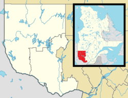 Cascades-Malignes Location in western Quebec. | |
| Coordinates: 47°07′N 76°06′W / 47.117°N 76.100°WCoordinates: 47°07′N 76°06′W / 47.117°N 76.100°W[1] | |
| Country |
|
| Province |
|
| Region | Outaouais |
| RCM | La Vallée-de-la-Gatineau |
| Constituted | January 1, 1986 |
| Government[2] | |
| • Federal riding | Pontiac |
| • Prov. riding | Gatineau |
| Area[2][3] | |
| • Total | 545.90 km2 (210.77 sq mi) |
| • Land | 486.40 km2 (187.80 sq mi) |
| Population (2011)[3] | |
| • Total | 0 |
| • Density | 0.0/km2 (0/sq mi) |
| • Pop (2006–11) |
|
| • Dwellings | 0 |
| Time zone | UTC−5 (EST) |
| • Summer (DST) | UTC−4 (EDT) |
Cascades-Malignes is an unorganized territory in the Outaouais region of Quebec, Canada, one of five unorganized territories in the La Vallée-de-la-Gatineau Regional County Municipality.
The territory is named after the Cascades Malignes (French for "Malicious Cascades") which are a series of chutes on the Gens de Terre River. This river forms the eastern boundary of the territory and of the La Vérendrye Wildlife Reserve as well. The log drivers who went down this river had nicknamed it La Maline (malignant) because its flow hid many obstacles. It is also known as Malin Rapides.[4]
Demographics
Population trend:
- Population in 2011: 0
- Population in 2006: 0
- Population in 2001: 0
References
- ↑ Reference number 149851 of the Commission de toponymie du Québec (in French)
- 1 2 Geographic code 83904 in the official Répertoire des municipalités (in French)
- 1 2 "(Code 2483904) Census Profile". 2011 census. Statistics Canada. 2012.
- ↑ "Cascades Malignes" (in French). Commission de toponymie du Québec. Retrieved 2008-08-19.
Places adjacent to Cascades-Malignes, Quebec | ||||||||||
|---|---|---|---|---|---|---|---|---|---|---|
| ||||||||||
| Cities | |
|---|---|
| Municipalities | |
| Townships | |
| Unorganized territories | |
| |
This article is issued from
Wikipedia.
The text is licensed under Creative Commons - Attribution - Sharealike.
Additional terms may apply for the media files.