Cascade, Missouri
| Cascade | |
|---|---|
| Unincorporated community | |
 Cascade Location within the state of Missouri | |
| Coordinates: 37°17′58″N 90°16′09″W / 37.29944°N 90.26917°WCoordinates: 37°17′58″N 90°16′09″W / 37.29944°N 90.26917°W | |
| Country | United States |
| State | Missouri |
| County | Wayne |
| Elevation | 525 ft (160 m) |
| Time zone | UTC-6 (Central (CST)) |
| • Summer (DST) | UTC-5 (CDT) |
| ZIP codes | old 63632 closed in 2004 or 05 |
| GNIS feature ID | 715465[1] |
Cascade is an unincorporated community in northeastern Wayne County, Missouri, United States. It is located on Missouri Supplemental Route M about eighteen miles west of Marble Hill. The community is on Little Creek just south of Big Creek. The community of Gravelton is one mile to the east on Big Creek.[2]
History
A post office called Cascade has been in operation since 1910.[3] The community was named for a series of waterfalls near the original town site.[4]
References
- ↑ "Cascade, Missouri". Geographic Names Information System. United States Geological Survey.
- ↑ Missouri Atlas & Gazetteer, DeLorme, 1998, First edition, p. 57, ISBN 0-89933-224-2
- ↑ "Post Offices". Jim Forte Postal History. Retrieved 1 January 2017.
- ↑ "Wayne County Place Names, 1928–1945". The State Historical Society of Missouri. Archived from the original on June 24, 2016. Retrieved January 1, 2017.
Municipalities and communities of Wayne County, Missouri, United States | ||
|---|---|---|
| Cities | 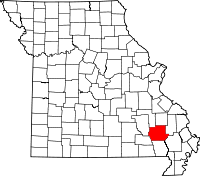 | |
| Village | ||
| Townships | ||
| Unincorporated communities | ||
| Ghost towns | ||
This article is issued from
Wikipedia.
The text is licensed under Creative Commons - Attribution - Sharealike.
Additional terms may apply for the media files.