Carsington
| Carsington | |
|---|---|
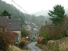 Carsington village | |
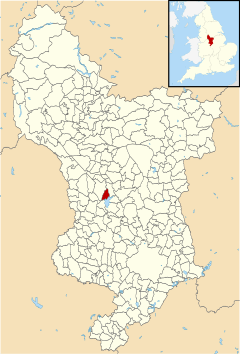 Carsington parish highlighted within Derbyshire | |
| Population | 251 (including Godfreyhole, 2011) |
| OS grid reference | SK250534 |
| District | |
| Shire county | |
| Region | |
| Country | England |
| Sovereign state | United Kingdom |
| Post town | MATLOCK |
| Postcode district | DE4 |
| Police | Derbyshire |
| Fire | Derbyshire |
| Ambulance | East Midlands |
| EU Parliament | East Midlands |
Carsington is a village in the middle of the Derbyshire Dales, England; it adjoins the hamlet of Hopton, and is close to the historic town of Wirksworth and village of Brassington.
According to the 1991 Census, the population was 111,[1] increasing to 251 at the 2011 Census.[2]
History
Carsington has a long history, including Roman occupation (an old Roman settlement now lies beneath the reservoir).[3] In prehistoric times, woolly rhinos lived in the area; the remains of one such animal were discovered nearby in the "Dream Cave" adjacent to the Callow and Hopton end of Summer Lane in the late 20th century.
Carsington is recorded in Domesday Book of 1086 as one of the berewicks (supporting farms) of the town and manor of Wirksworth. During the middle ages and right up until about 1800 it was a major location for lead mining and the lead obtained in the many Brassington and Carsington mines was usually smelted in Wirksworth.
The Channel 4 archaeology series Time Team once visited Carsington to investigate the archaeology and ancient remains in the pastures, where they visited a cave, discovered by the Pegasus Caving Club, full of ancient human bones.[4]
British aurochs specimen CPC98 was retrieved in 1998 from Carsington Pasture Cave, possess P mtDNA haplogroup sequences and radiocarbon dated to 6,738 ± 68 calibrated years BP.[5] An auroch is a kind of wild cattle.
Carsington today
Today, Carsington has one pub, the Miner's Arms, and a primary school. The community is primarily composed of a strong commuter and retiree contingent to replace the traditional agricultural, mining and quarrying community.
Carsington Reservoir, opened in 1992, stores water from the River Derwent and is operated by Severn Trent Water. It is open all year for recreation, with an extensive cycle path, several bird hides, a water sports and sailing centre. Inside the visitor centre are a trail, several specialist shops including an excellent and informative RSPB shop, and a café/restaurant.
The nearest railway station to Carsington is Wirksworth on the Ecclesbourne Valley Railway
References
- ↑ (1991 Census)
- ↑ "Civil Parish population 2011". Neighbourhood Statistics. Office for National Statistics. Retrieved 22 March 2016.
- ↑ There has been some discussion about the whereabouts of a Roman city known as Lutudarum. Anton Shone has recently published a well-referenced paper on the possible location of Lutudarm (link broken January 2015): "Origins and History of Wirksworth: Lutudarum and the Peak District before the Norman Conquest" "Archived copy" (PDF). Archived from the original (PDF) on 2011-10-02. Retrieved 2009-04-01.
- ↑ "Carsington Derbyshire". Channel 4. Retrieved 26 July 2011.
- ↑ Stephen D E Park et al. Genome sequencing of the extinct Eurasian wild aurochs, Bos primigenius, illuminates the phylogeography and evolution of cattle, Genome Biology (2015) 16:234.
External links
![]()