Carrollton Township, Carroll County, Arkansas
| Carrollton Township | |
|---|---|
| Township | |
 Carrollton Township Location in Arkansas | |
| Coordinates: 36°14′38.32″N 93°20′23.99″W / 36.2439778°N 93.3399972°WCoordinates: 36°14′38.32″N 93°20′23.99″W / 36.2439778°N 93.3399972°W | |
| Country |
|
| State |
|
| County | Carroll |
| Area | |
| • Total | 35.742 sq mi (92.57 km2) |
| • Land | 35.734 sq mi (92.55 km2) |
| • Water | 0.008 sq mi (0.02 km2) |
| Population (2010) | |
| • Total | 716 |
| • Density | 20.04/sq mi (7.74/km2) |
| Time zone | UTC-6 (CST) |
| • Summer (DST) | UTC-5 (CDT) |
| Zip Code | 72611 (Alpena) |
| Area code(s) | 870 |
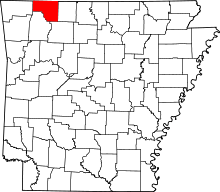
Carrollton Township is one of twenty-one current townships in Carroll County, Arkansas, USA.[1] As of the 2010 census, its total population was 716.
Carrollton Township was formed prior to 1870; the exact date is unknown since county records were lost.[2]
Geography
According to the United States Census Bureau, Carrollton Township covers an area of 35.742 square miles (92.57 km2); 35.734 square miles (92.55 km2) of land and 0.008 square miles (0.021 km2) of water.
Cities, towns, and villages
- Alpena (part)
- Carrollton (unincorporated)
References
- United States Census Bureau 2008 TIGER/Line Shapefiles
- United States Board on Geographic Names (GNIS)
- United States National Atlas
- ↑ "Carrollton Township, Carroll County, Arkansas." U.S. Census Bureau. Breakdown. Retrieved June 3, 2012.
- ↑ History of Benton, Washington, Carroll, Madison, Crawford, Franklin, and Sebastian Counties, Arkansas. Higginson Book Company. 1889. p. 359.
External links
This article is issued from
Wikipedia.
The text is licensed under Creative Commons - Attribution - Sharealike.
Additional terms may apply for the media files.
