Carrollton Covered Bridge
|
Carrollton Covered Bridge | |
 | |
  | |
| Location | Carrollton, West Virginia |
|---|---|
| Coordinates | 39°5′24.23″N 80°5′12.19″W / 39.0900639°N 80.0867194°WCoordinates: 39°5′24.23″N 80°5′12.19″W / 39.0900639°N 80.0867194°W |
| Built | 1856 |
| Architect | O'Brien, Emmet J.; O'Brien, Daniel |
| Architectural style | Other |
| NRHP reference # | 81000595[1] |
| Added to NRHP | June 4, 1981 |
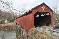
The Carrollton Covered Bridge, in Barbour County, West Virginia, U.S., is the second longest and third oldest surviving covered bridge in the state. The wooden bridge spans the Buckhannon River near Carrollton and was built in 1856 by Emmet J. O'Brien and Daniel O'Brien. It is 140 feet 9 inches (42.90 m) long and 16 feet (4.9 m) wide, with kingpost trusses supported by concrete piers and abutments.[2] It underwent repairs in 1978 and was added to the National Register of Historic Places on June 4, 1981.
The bridge was heavily damaged in a fire on August 10, 2017.[3]
See also
References
- ↑ National Park Service (2006-03-15). "National Register Information System". National Register of Historic Places. National Park Service.
- ↑ "NRHP nomination for Carrollton Covered Bridge". National Park Service. Retrieved June 7, 2016.
- ↑ Jenkins, Jeff (August 11, 2017). "Covered bridge's future uncertain following fire". MetroNews. Retrieved August 11, 2017.
| Topics |  | |
|---|---|---|
| Lists by county |
| |
| Other lists | ||
| ||
This article is issued from
Wikipedia.
The text is licensed under Creative Commons - Attribution - Sharealike.
Additional terms may apply for the media files.