Carrodano
| Carrodano | |
|---|---|
| Comune | |
| Comune di Carrodano | |
 Carrodano | |
 Carrodano Location of Carrodano in Italy | |
| Coordinates: 44°15′N 9°39′E / 44.250°N 9.650°ECoordinates: 44°15′N 9°39′E / 44.250°N 9.650°E | |
| Country | Italy |
| Region | Liguria |
| Province | Province of La Spezia (SP) |
| Area | |
| • Total | 21.0 km2 (8.1 sq mi) |
| Population (Dec. 2004) | |
| • Total | 532 |
| • Density | 25/km2 (66/sq mi) |
| Time zone | UTC+1 (CET) |
| • Summer (DST) | UTC+2 (CEST) |
| Postal code | 19020 |
| Dialing code | 0187 |
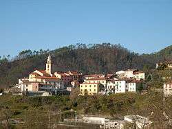
Carrodano (Ligurian: Carreu, locally Caröa[1]) is a comune (municipality) in the Province of La Spezia in the Italian region Liguria, located about 60 kilometres (37 mi) southeast of Genoa and about 20 kilometres (12 mi) northwest of La Spezia. As of 31 December 2004, it had a population of 532 and an area of 21.0 square kilometres (8.1 sq mi).[2]
Carrodano borders the following municipalities: Borghetto di Vara, Carro, Deiva Marina, Framura, Levanto, Sesta Godano.
Demographic evolution

References
- ↑ Frisoni, Gaetano (1910). Dizionario Genovese-Italiano e Italiano-Genovese (in Italian). Genoa: Nuova Editrice Genovese.
- ↑ All demographics and other statistics: Italian statistical institute Istat.
This article is issued from
Wikipedia.
The text is licensed under Creative Commons - Attribution - Sharealike.
Additional terms may apply for the media files.