Cardonia, Indiana
| Cardonia | |
|---|---|
| Unincorporated community | |
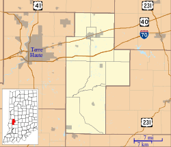 Cardonia Location in Clay County | |
| Coordinates: 39°33′42″N 87°06′28″W / 39.56167°N 87.10778°WCoordinates: 39°33′42″N 87°06′28″W / 39.56167°N 87.10778°W | |
| Country | United States |
| State | Indiana |
| County | Clay |
| Township | Van Buren |
| Elevation | 682 ft (208 m) |
| ZIP code | 47834 |
| FIPS code | 18-10234[1] |
| GNIS feature ID | 432127[2] |
Cardonia is an unincorporated community in Van Buren Township, Clay County, Indiana. It is part of the Terre Haute Metropolitan Statistical Area.
History
Cardonia was founded in the year 1871 as a coal mining town.[3] It was named for John F. Card, a mining official.[4] A post office was established in Cardonia in 1879, and remained in operation until it was discontinued in 1909.[5]
Geography
Cardonia is located at 39°33′42″N 87°06′28″W / 39.56167°N 87.10778°W.
References
- ↑ "American FactFinder". United States Census Bureau. Archived from the original on 2013-09-11. Retrieved 2008-01-31.
- ↑ "Cardonia, Indiana". Geographic Names Information System. United States Geological Survey. Retrieved 2009-10-10.
- ↑ Blanchard, Charles (1884). Counties of Clay and Owen, Indiana: Historical and Biographical. F.A. Battey & Company. p. 248.
- ↑ Baker, Ronald L. (October 1995). From Needmore to Prosperity: Hoosier Place Names in Folklore and History. Indiana University Press. p. 87. ISBN 978-0-253-32866-3.
...and named for John F. Card, then president of the company.
- ↑ "Clay County". Jim Forte Postal History. Archived from the original on 3 September 2014. Retrieved 30 August 2014.
Municipalities and communities of Clay County, Indiana, United States | ||
|---|---|---|
| City | ||
| Towns | ||
| Townships | ||
| CDP | ||
| Other unincorporated communities |
| |
| Ghost towns | ||
| Footnotes | ‡This populated place also has portions in an adjacent county or counties | |
This article is issued from
Wikipedia.
The text is licensed under Creative Commons - Attribution - Sharealike.
Additional terms may apply for the media files.