Carapelle Calvisio
| Carapelle Calvisio | ||
|---|---|---|
| Comune | ||
| Comune di Carapelle Calvisio | ||
 | ||
| ||
 Carapelle Calvisio Location of Carapelle Calvisio in Italy | ||
| Coordinates: 42°18′1″N 13°41′8″E / 42.30028°N 13.68556°ECoordinates: 42°18′1″N 13°41′8″E / 42.30028°N 13.68556°E | ||
| Country | Italy | |
| Region | Abruzzo | |
| Province | L'Aquila (AQ) | |
| Government | ||
| • Mayor | Domenico Di Cesare | |
| Area | ||
| • Total | 14.39 km2 (5.56 sq mi) | |
| Elevation | 910 m (2,990 ft) | |
| Population (31 December 2013)[1] | ||
| • Total | 85 | |
| • Density | 5.9/km2 (15/sq mi) | |
| Demonym(s) | Carapellesi | |
| Time zone | UTC+1 (CET) | |
| • Summer (DST) | UTC+2 (CEST) | |
| Postal code | 67020 | |
| Dialing code | 0862 | |
| Patron saint | San Pancrazio martire | |
| Saint day | 12 May | |
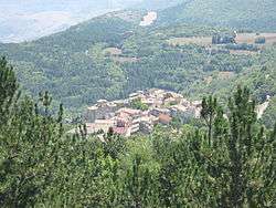
Carapelle Calvisio is a comune and town in the province of L'Aquila in the Abruzzo region of central Italy. It is located in the natural park known as the Gran Sasso e Monti della Laga National Park at 900 metres (3,000 ft) above sea level. It is mostly known as being one of the smallest non-alpine comunes in Italy, with 85 inhabitants as of 31 December 2013. It is located directly some kilometers from the historical castle Rocca Calascio.
Carapelle Calvisio's location (separated by a mountain from L'Aquila area) preserved it from serious damage in the April 2009 L'Aquila earthquake.
References
External links

This article is issued from
Wikipedia.
The text is licensed under Creative Commons - Attribution - Sharealike.
Additional terms may apply for the media files.