Campotosto
| Campotosto | |
|---|---|
| Comune | |
| Comune di Campotosto | |
 | |
 Campotosto Location of Campotosto in Italy | |
| Coordinates: 42°33′35″N 13°22′8″E / 42.55972°N 13.36889°ECoordinates: 42°33′35″N 13°22′8″E / 42.55972°N 13.36889°E | |
| Country | Italy |
| Region | Abruzzo |
| Province | L'Aquila (AQ) |
| Frazioni | Mascioni, Ortolano, Poggio Cancelli, Rio Fucino, San Pelino, San Potito |
| Government | |
| • Mayor | Antonio Di Carlantonio |
| Area | |
| • Total | 51.74 km2 (19.98 sq mi) |
| Elevation | 1,420 m (4,660 ft) |
| Population (2013) | |
| • Total | 580 |
| • Density | 11/km2 (29/sq mi) |
| Demonym(s) | Campotostari |
| Time zone | UTC+1 (CET) |
| • Summer (DST) | UTC+2 (CEST) |
| Postal code | 67103 |
| Dialing code | 0862 |
| Patron saint | Maria Santissima della Visitazione |
| Saint day | July 2 |
| Website | Official website |
Campotosto (Sabino: Camputotsu) is a comune and town in the province of L'Aquila, in the Abruzzo region of central Italy. Olympian Mariano Antonelli was born here.[1]
Geography
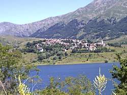
Campotosto is located in the northern part of the province of L'Aquila, south of the border with Lazio, and west of the province of Teramo. It is located in Gran Sasso e Monti della Laga National Park. The town has become famous in Italy for its lake, which is the biggest Italian man-made lake.[2]
Accessibility
The town is served by Italian State Highway 80 a Trunk road that connect L'Aquila with Giulianova (TE). There are also secondary roads that connect Campotosto with Amatrice, Montereale, Aringo and Capitignano.[3]
Climate
The town has a typical Alpine climate (partially mitigated by the lake): cold and snowy in winter, fresh and windy in summer.[4]
References
- ↑ "Mariano Antonelli". Sports Reference. Retrieved 6 July 2015.
- ↑ http://www.ise.cnr.it/limno/schede/campotosto.htm
- ↑ http://www.stradeanas.it/
- ↑ http://clisun.casaccia.enea.it/profili/tabelle/443%20%5BCampotosto%5D%20capoluogo.Txt
