Capps, Arkansas
| Capps, Arkansas | |
|---|---|
| Unincorporated community | |
 Capps, Arkansas  Capps, Arkansas | |
| Coordinates: 36°14′08″N 93°11′22″W / 36.23556°N 93.18944°WCoordinates: 36°14′08″N 93°11′22″W / 36.23556°N 93.18944°W | |
| Country | United States |
| State | Arkansas |
| County | Boone |
| Elevation | 1,440 ft (440 m) |
| Time zone | UTC-6 (Central (CST)) |
| • Summer (DST) | UTC-5 (CDT) |
| Area code(s) | 870 |
| GNIS feature ID | 57506[1] |
Capps is an unincorporated community in Boone County, Arkansas, United States. Capps is located on Arkansas Highway 392, 4.6 miles (7.4 km) west of Harrison.[2]
References
- ↑ "Capps". Geographic Names Information System. United States Geological Survey.
- ↑ Boone County, Arkansas General Highway Map (PDF) (Map). Arkansas State Highway and Transportation Department. 2002. Retrieved January 6, 2012.
Municipalities and communities of Boone County, Arkansas, United States | ||
|---|---|---|
| Cities | 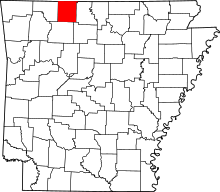 | |
| Towns | ||
| Townships | ||
| Unincorporated communities | ||
| Ghost town | ||
| Footnotes | ‡This populated place also has portions in an adjacent county or counties | |
This article is issued from
Wikipedia.
The text is licensed under Creative Commons - Attribution - Sharealike.
Additional terms may apply for the media files.