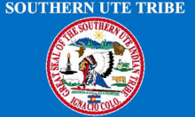
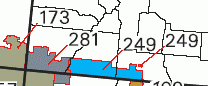
Southern Ute Indian Reservation
The Southern Ute Indian Reservation is a Native American reservation in southwestern Colorado near the northern New Mexico state line. Its territory consists of land from three counties; in descending order of surface area they are La Plata, Archuleta, and Montezuma Counties. The reservation has a land area of 1,058.785 sq mi (2,742.24 km²). Its largest communities are Ignacio and Arboles.[1] The only other community that is recognized as a separate place by the Census Bureau is the CDP of Southern Ute, which lies just southeast of Ignacio.
History
Historic bands
The Southern Ute tribes include the Muache, Capote, and the Weeminuche, the latter of which are at Ute Mountain. These tribes were considered the Southern Utes.
Capote
The Capote (Kapota, Kahpota) band lived east of the Great Divide south of the Conejos River and east of the Rio Grande towards the west site of the Sangre de Cristo Mountains, they were also living in the San Luis Valley, along the headwaters of the Rio Grande and along the Animas River, centered in the vicinity of today Chama and Tierra Amarilla of Rio Arriba County. Like the Mahgrahch the Kahpota maintained trade relations to Puebloan peoples and came into conflict with southern plains people because of their alliance with the Ollero band of the Jicarilla Apache.[2]
Muache
The Muache (Mouache, Mahgruhch, Mahgrahch, Muwac) band lived along the eastern foothills of the Rocky Mountains from Denver, Colorado in the north to Las Vegas, New Mexico in the south, traded with northern Puebloan peoples, especially with Taos Pueblo, therefore often called Taos-Ute, ranged after adoption of the horse with their allies, the Llanero band of the Jicarilla Apache, southeastward as far as the Texas Panhandle.
Treaties with the U.S. government
Ouray of the Uncompahgre band was appointed by President Abraham Lincoln as head of all Ute tribes, which was not agreed upon by the Southern Ute bands. The first reservation created by the treaty of 1868 encompassed about 1/3 of present-day Colorado, mostly the mountainous regions west of the continental divide. When precious metals and minerals were discovered in the central mountains settlers sought access to the land. In 1873 The Brunot Agreement was created. This agreement limited the reservation to the narrow strip of land that is called The Southern Ute Reservation today. The United States also made treaties with various bands of Ute in 1855, 1865, and 1866, which the Senate failed to ratify. Initially given the whole of eastern Colorado for a reservation, the discovery of gold there in the 1860s brought a quick reduction in territory. The treaty with the Ute in 1865 provided for the cession of land in exchange for the entire valley of the Uintah River in Utah, plus $25,000 per year for ten years, then $20,000 for 20 years, and thereafter $15,000 per year, based on an estimated population of 5,000 Ute. The treaty also banned liquor and provided for the establishment and maintenance of a manual labor school for ten years.[3]
Reservation
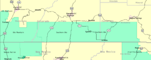
The Southern Ute Indian Reservation was opened in southwestern Colorado. The eastern part of the reservation is forest with elevations of more than 9000 feet. The western portion is mostly arid mesa. The actual land lies in the southwestern corner of the state of Colorado and consists of a strip fifteen miles wide (north to south) an In 1895 The Hunter Act distributed the land in the reservation in plots to the heads of households in the Mouache and Capote tribes. The Weeminuche tribe had approved an 1888 congressional bill relocating them to San Juan County, Utah, however this bill did not pass so the Weeminuche were brought back to Colorado. They refused to go back to the old grounds of the agency so they established camps on the western end of the Southern Ute Reservation. With the three tribes given their land the final provisions of the Hunter Act were implemented opening over 500,000 acres of the Reservation to non-native settlers.
Established in 1873, it is the reservation of the Southern Ute Indian Tribe, a federally recognized Ute tribe. The southern Utes are made up of two bands, the Mouache and the Capote. Government is organized under the Indian Reorganization Act of 1934 and is led by a tribal council with a chairman as head of the executive. For decades at the end of the 20th century, Leonard C. Burch had been the tribes chairman. In 2008 a new chairman, Matthew Box was elected.[4] There have been numerous council members, with some being elected to council many times, but they all serve one purpose, and that is to serve the tribal membership for their best interest. Leonard C. Burch was the most popular chairman to ever serve for the tribal population. When Matthew Box was elected he won in a runoff election against Clement J. Frost. The Southern Ute Indian Tribe is currently the largest employer in the Four Corners, being a stupendous and competitive organization. With being on the top-ten list of wealthiest tribes in America, the Southern Utes also put their priority to their spiritual traditions as well as their compatibility towards the non-Indian people. They supply numerous non-Indians with employment that benefits themselves in many ways. By creating a "checkerboard reservation", the Southern Utes created a relationship with the non-Indians that they knew was imminent.
Census
Census population in Southern Ute Reservation in 1980 and 20 years later, 2000.
Southern Ute Reservation  1980  2000
       Archuleta County  2,257  4,796
        La Plata County    259    695
       Montezuma County  1,998  4,101
Tribal chairman
Matthew Box resigned as Tribal Chairman in 2011. Under a special election Pearl Casias was elected as the first Chairwoman in the history of the Tribe and served for a time in 2011.[5] Jimmy Newton served as Tribal Chairman from 2012 until his death in 2014.[6] Clement Frost served as Tribal Chairman following Newton's death in 2014.[7] Frost retired in 2017, and in December 2017 Christine Baker-Sage was elected to serve as Tribal Chairwoman.[8]
Notable people
- Joseph Rael, (b. 1935), dancer, author, and spiritualist
See also
Notes
- ↑ Southern Ute Reservation, Colorado United States Census Bureau.
- ↑ "Chapter Five - The Northern Utes of Utah". utah.gov.
- ↑ Treaty Making: Southern Plains and the Southwest." In The American Mosaic: The American Indian . : , 2014. .
- ↑ "New Ute tribal chairman Matthew Box sworn in " News From Indian Country December 2008
- ↑ Southern Ute Indian Tribe.Chairmen. Retrieved: 2017-05-05.
- ↑ Indian Country Today. Southern Utes Mourn Loss of Tribal Chairman Jimmy Newton Jr., April 3, 2014. Retrieved: 2017-05-05.
- ↑ Mazur, Melanie Brubaker (2014-12-15). "Clement Frost returns as tribal chairman". The Durango Herald. Retrieved 2017-05-05.
- ↑ Rupani, Mia (2017-12-16). "Southern Utes usher in new leadership". The Durango Herald. Retrieved 2017-12-18.
References
- Pritzker, Barry M. A Native American Encyclopedia: History, Culture, and Peoples. Oxford: Oxford University Press, 2000. ISBN 978-0-19-513877-1.
External links
- The Southern Ute Indian Tribe, official website
Coordinates: 37°06′30″N 107°38′42″W / 37.10833°N 107.64500°W
| Overview | |||||||||
|---|---|---|---|---|---|---|---|---|---|
| Contemporary peoples native to Colorado |
| ||||||||
| Prehistoric cultures in Colorado |
| ||||||||
| Related articles | |||||||||
Municipalities and communities of Archuleta County, Colorado, United States | ||
|---|---|---|
| Town | 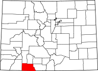 | |
| CDP | ||
| Unincorporated communities | ||
| Indian reservation | ||
| Footnotes | ‡This populated place also has portions in an adjacent county or counties | |
Municipalities and communities of La Plata County, Colorado, United States | ||
|---|---|---|
| City | 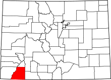 | |
| Towns | ||
| CDP | ||
| Unincorporated communities | ||
| Indian reservations | ||
| Ghost towns |
| |
| Footnotes | ‡This populated place also has portions in an adjacent county or counties | |
Municipalities and communities of Montezuma County, Colorado, United States | ||
|---|---|---|
| City |  | |
| Towns | ||
| CDP | ||
| Unincorporated communities | ||
| Indian reservations | ||
| Footnotes | ‡This populated place also has portions in an adjacent county or counties | |