Cape Fear Memorial Bridge
| Cape Fear Memorial Bridge | |
|---|---|
 | |
| Coordinates | 34°13′41″N 77°57′08″W / 34.2280°N 77.9521°WCoordinates: 34°13′41″N 77°57′08″W / 34.2280°N 77.9521°W |
| Carries |
|
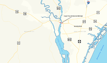
| Crosses | Cape Fear River |
| Locale | Wilmington, North Carolina |
| Official name | Cape Fear Memorial Bridge |
| Maintained by | North Carolina Department of Transportation |
| Characteristics | |
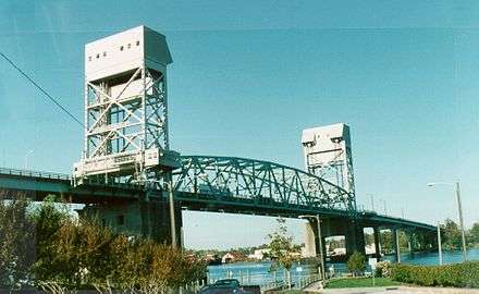
| Design | Vertical lift bridge |
| Total length | 924.5 m (3,033 ft) |
| Width | 16.5 m (54 ft) (4 lanes) |
| Longest span | 408 feet (124 m)[1] |
| Load limit | 46.8 tonnes |
| Clearance below | 21 m (69 ft) |
| History | |
| Opened | October 1, 1969 |
 | |
The Cape Fear Memorial Bridge is a steel vertical-lift bridge in North Carolina. It carries US 17/US 76/US 421 across the Cape Fear River between Brunswick County and New Hanover County. It also carried U.S. Route 74 until that designation was shifted to the Isabel S. Holmes Bridge. It features a lift span that can be raised 135 feet (41 m).[2] The lift span is 408 feet (124 m) long.[1]
History
Gallery

.jpg)

See also


- Interstate 140 (North Carolina)
- USS North Carolina (BB-55)
References
- 1 2 Barefoot, Daniel W. (1995). Touring the Backroads of North Carolina's Lower Coast. John F. Blair. p. 194. ISBN 978-0-89587-126-8. Retrieved August 14, 2011.
- ↑ State Bridge Records Archived July 9, 2006, at the Wayback Machine. Accessed June 30, 2006.
External links
| Wikimedia Commons has media related to Cape Fear Memorial Bridge. |
This article is issued from
Wikipedia.
The text is licensed under Creative Commons - Attribution - Sharealike.
Additional terms may apply for the media files.