| Name |
Address |
Coordinates |
IDF |
IDP |
IDM |
 |
Image |
|---|
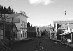
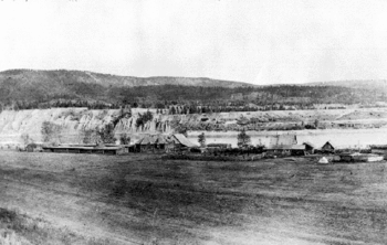
| Barkerville |
, Cariboo Regional District, BC |
53°3′57″N 121°31′2″W / 53.06583°N 121.51722°W / 53.06583; -121.51722 (Barkerville) |
14309 |
1749 |
|
Q808269 |
More images |
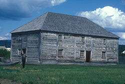
| Fish Cache |
, Fort St. James, BC |
54°26′06″N 124°15′22″W / 54.435°N 124.256°W / 54.435; -124.256 (Fish Cache) |
2961 |
|
|
|
 |
| General Warehouse |
, Fort St. James, BC |
54°26′06″N 124°15′22″W / 54.435°N 124.256°W / 54.435; -124.256 (General Warehouse) |
2963 |
|
|
|
|
| St. Andrew's Church |
, Bennett Lake, BC |
59°46′09″N 135°07′05″W / 59.7692°N 135.118°W / 59.7692; -135.118 (St. Andrew's Church) |
3653 |
|
|
|

More images |
| Men's House |
, Fort St. James, BC |
54°26′06″N 124°15′25″W / 54.435°N 124.257°W / 54.435; -124.257 (Men's House) |
3665 |
|
|
|
|
| Officer's Dwelling |
, Fort St. James, BC |
54°26′06″N 124°15′25″W / 54.435°N 124.257°W / 54.435; -124.257 (Officer's Dwelling) |
3666 |
|
|
|
|
| Fort St. James National Historic Site of Canada |
PO Box 1148, Fort St. James, BC |
54°26′07″N 124°15′25″W / 54.4352°N 124.257°W / 54.4352; -124.257 (Fort St. James National Historic Site of Canada) |
7617 |
|
|
|
 |
| Chilkoot Trail National Historic Site of Canada |
, Cassiar, BC |
59°46′02″N 135°06′36″W / 59.7673°N 135.11°W / 59.7673; -135.11 (Chilkoot Trail National Historic Site of Canada) |
9087 |
|
|
|

More images |
| Federal Building |
10401 10th Street, Dawson Creek, Peace River Country, BC |
|
9522 |
|
|
|
|
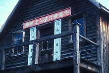
| Chee Kung Tong Building National Historic Site of Canada |
Box 19, Barkerville, BC |
53°04′00″N 121°31′01″W / 53.0667°N 121.517°W / 53.0667; -121.517 (Chee Kung Tong Building National Historic Site of Canada) |
11971 |
|
|
|
 |
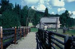
| Cottonwood House |
4660 Highway 26, Cottonwood, BC |
53°03′02″N 122°09′25″W / 53.0505°N 122.157°W / 53.0505; -122.157 (Cottonwood House) |
|
15813 |
|
|
 |
| Fort McLeod National Historic Site of Canada |
Carp Lake Road, Fort McLeod Historic Park, McLeod Lake, BC |
54°59′00″N 123°03′00″W / 54.9833°N 123.05°W / 54.9833; -123.05 (Fort McLeod National Historic Site of Canada) |
16523 |
|
|
|
 |
| McLeod's Lake Post |
Old Carp Lake Road, McLeod Lake, BC |
54°59′35″N 123°02′20″W / 54.993°N 123.039°W / 54.993; -123.039 (McLeod's Lake Post) |
|
16592 |
|
|
 |
| Canadian National Railway Station |
Main Street at Railway Avenue, Smithers, BC |
54°46′41″N 127°10′33″W / 54.778026°N 127.175833°W / 54.778026; -127.175833 (Canadian National Railway Station (Smithers)) |
6493 |
|
|
|
|
| Canadian National Railway Station |
First Avenue and Main Street, McBride, BC |
53°18′04″N 120°10′12″W / 53.301003°N 120.169973°W / 53.301003; -120.169973 (Canadian National Railway Station (McBride)) |
6631 |
|
|
|
|
| Fort Alexandria National Historic Site of Canada |
, Alexandria, BC |
52°33′47″N 122°28′48″W / 52.563°N 122.48°W / 52.563; -122.48 (Fort Alexandria National Historic Site of Canada) |
17741 |
|
|
|
 |
| 108 Mile Heritage Site |
Highway 97, 108 Mile Ranch, BC |
51°45′00″N 121°20′53″W / 51.7501°N 121.348°W / 51.7501; -121.348 (108 Mile Heritage Site) |
|
|
18409 |
|
 |
| 150 Mile Little Red Schoolhouse |
3081 Old Schoolhouse Road, 150 Mile House, BC |
52°06′28″N 121°55′40″W / 52.1079°N 121.9277°W / 52.1079; -121.9277 (150 Mile Little Red Schoolhouse) |
|
|
18749 |
|
|
| 150 Mile Courthouse |
Highway 97, 150 Mile House, BC |
52°06′35″N 121°55′42″W / 52.1097°N 121.9284°W / 52.1097; -121.9284 (150 Mile Courthouse) |
|
|
19032 |
|
|
| Knoll House |
, Chilanko Forks, BC |
|
|
|
19031 |
|
|
| Telegraph Trail |
Roughly, Highway 97 in the Cariboo Regional District, Cariboo Regional District, BC |
51°45′04″N 121°20′55″W / 51.7511°N 121.3487°W / 51.7511; -121.3487 (Telegraph Trail) |
|
|
20623 |
|
|
| Blessing's Grave |
Highway 26, 43 km east of Quesnel, Pinegrove, BC |
53°03′48″N 121°56′53″W / 53.0632°N 121.948°W / 53.0632; -121.948 (Blessing's Grave) |
|
21414 |
|
|
|
| Potato House |
49 Borland Street, Williams Lake, BC |
52°07′47″N 122°08′46″W / 52.1296°N 122.1462°W / 52.1296; -122.1462 (Potato House) |
|
20622 |
|
|
|