| Name |
Address |
Coordinates |
IDF |
IDP |
IDM |
 |
Image |
|---|
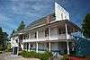
| Abbotsford Sikh Temple National Historic Site of Canada |
33089 South Fraser Way, Abbotsford, BC |
49°03′03″N 122°18′29″W / 49.0508°N 122.308°W / 49.0508; -122.308 (Abbotsford Sikh Temple National Historic Site of Canada) |
9358 |
|
5878 |
|
More images |
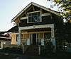
| Agassiz Research Station, Building No. 13 |
6947 Highway 7, Agassiz, BC |
49°14′34″N 121°45′48″W / 49.242712°N 121.763257°W / 49.242712; -121.763257 (Agassiz Research Station, Building No. 13) |
4381 |
|
|
|
 |
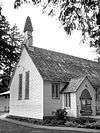
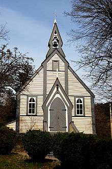
| Clayburn Church |
4304 Wright Street, Abbotsford, BC |
49°04′49″N 122°15′40″W / 49.0803°N 122.261°W / 49.0803; -122.261 (Clayburn Church) |
|
|
5881 |
|

More images |
| Clayburn School |
4315 Wright Street, Abbotsford, BC |
49°04′51″N 122°15′43″W / 49.0807°N 122.262°W / 49.0807; -122.262 (Clayburn School) |
|
|
5882 |
|

More images |
| Trethewey House |
2313 Ware Street, Abbotsford, BC |
49°02′37″N 122°18′18″W / 49.0437°N 122.305°W / 49.0437; -122.305 (Trethewey House) |
|
|
5880 |
|
More images |
| Brigadier Murphy Armoury |
29th & 21st Avenue, Canadian Forces Base Chilliwack, Chilliwack, BC |
50°15′21″N 119°16′08″W / 50.2559°N 119.269°W / 50.2559; -119.269 (Brigadier Murphy Armoury) |
9504 |
|
|
|
|
| Building 24 |
45420 Vedder Mountain Road, Chilliwack, BC |
49°06′09″N 121°58′30″W / 49.1025°N 121.975°W / 49.1025; -121.975 (Building 24) |
11008 |
|
|
|
|
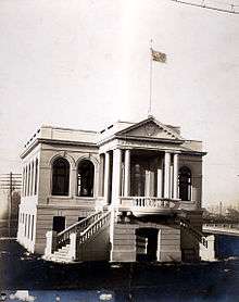
| Chilliwack City Hall National Historic Site of Canada |
45820 Spadina Avenue, Chilliwack, BC |
49°10′07″N 121°57′22″W / 49.1687°N 121.956°W / 49.1687; -121.956 (Chilliwack City Hall National Historic Site of Canada) |
7408 |
|
|
|
More images |
| Church of the Holy Cross National Historic Site of Canada |
, Skatin, BC |
49°56′16″N 122°24′36″W / 49.937710°N 122.410010°W / 49.937710; -122.410010 (Church of the Holy Cross National Historic Site of Canada) |
7410 |
|
|
|
|
| Kilby Store and Farm |
215 Kilby Road, Harrison Mills, BC |
49°14′16″N 121°57′36″W / 49.2378°N 121.96°W / 49.2378; -121.96 (Kilby Store and Farm) |
|
1748 |
|
|
More images |
| Christ Church National Historic Site of Canada |
681 Fraser Avenue, Hope, BC |
49°22′52″N 121°26′38″W / 49.381°N 121.444°W / 49.381; -121.444 (Christ Church National Historic Site of Canada) |
12564 |
|
|
|
More images |
| Fort Hope National Historic Site of Canada |
Corner of Wallace and Water Streets, Hope, BC |
49°22′43″N 121°26′39″W / 49.3785°N 121.4441°W / 49.3785; -121.4441 (Fort Hope National Historic Site of Canada) |
19613 |
|
|
|
|
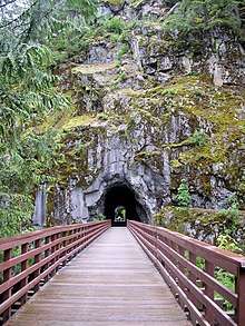
| Othello Tunnels |
, Hope, BC |
49°22′14″N 121°21′58″W / 49.3706°N 121.366°W / 49.3706; -121.366 (Othello Tunnels) |
|
18065 |
|
|
 |
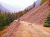
| Royal Engineers' Road |
, Hope, BC |
49°14′04″N 121°07′23″W / 49.2344°N 121.123°W / 49.2344; -121.123 (Royal Engineers' Road) |
|
18056 |
|
|
 |
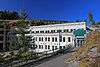
| Mission Memorial Centre |
33070 5th Avenue, Mission, BC |
49°08′17″N 122°18′28″W / 49.1380°N 122.3079°W / 49.1380; -122.3079 (Mission Memorial Centre) |
|
|
19414 |
|
|
| Mission Museum |
33201 2nd Avenue, Mission, BC |
49°08′07″N 122°18′17″W / 49.1354°N 122.3047°W / 49.1354; -122.3047 (Mission Museum) |
|
|
19413 |
|
|
| Silverhill Hall |
31016 Silverhill Avenue, Mission, BC |
49°10′36″N 122°21′53″W / 49.1767°N 122.3648°W / 49.1767; -122.3648 (Silverhill Hall) |
|
|
19426 |
|
|
| Stave Falls Hydro-Electric Installation National Historic Site of Canada |
, Mission, BC |
49°13′43″N 122°21′22″W / 49.2285°N 122.356°W / 49.2285; -122.356 (Stave Falls Hydro-Electric Installation National Historic Site of Canada) |
13213 |
|
19425 |
|
More images |
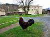
| Xá:ytem / Hatzic Rock National Historic Site of Canada |
35087 Lougheed Highway, Mission, BC |
49°09′04″N 122°15′04″W / 49.1512°N 122.251°W / 49.1512; -122.251 (Xá:ytem / Hatzic Rock National Historic Site of Canada) |
2256 |
|
|
|

More images |
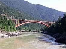
| Alexandra Bridge |
Old Highway 1, Spuzzum, BC |
49°42′27″N 121°25′01″W / 49.7075°N 121.417°W / 49.7075; -121.417 (Alexandra Bridge) |
|
18067 |
|
|
More images |
| Royal Engineers' Road at Alexandra Bridge |
, Spuzzum, BC |
49°42′26″N 121°24′50″W / 49.7071°N 121.414°W / 49.7071; -121.414 (Royal Engineers' Road at Alexandra Bridge) |
|
18042 |
|
|
 |
| Church of St. John the Divine |
Douglas Street, Yale, BC |
49°33′46″N 121°25′55″W / 49.5627°N 121.432°W / 49.5627; -121.432 (Church of St. John the Divine) |
|
6190 |
|
|
More images |