Camperdown, Victoria
| Camperdown Victoria | |||||||||
|---|---|---|---|---|---|---|---|---|---|
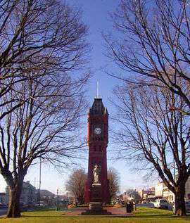 Manifold Street Camperdown looking east toward the clock tower and war memorial | |||||||||
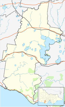 Camperdown Location in the Shire of Corangamite | |||||||||
| Coordinates | 38°14′S 143°09′E / 38.233°S 143.150°ECoordinates: 38°14′S 143°09′E / 38.233°S 143.150°E | ||||||||
| Population | 3,369 (2016 census)[1] | ||||||||
| Established | 1854 | ||||||||
| Postcode(s) | 3260 | ||||||||
| Elevation | 165 m (541 ft) | ||||||||
| Location |
| ||||||||
| LGA(s) | Corangamite Shire | ||||||||
| State electorate(s) | Polwarth | ||||||||
| Federal Division(s) | Wannon | ||||||||
| |||||||||
Camperdown (/ˈkæmpərdaʊn/)[2] is a historically significant rural town in southwestern Victoria, Australia, 190 kilometres (120 mi) west of the state capital, Melbourne. At the 2011 census, Camperdown had a population of 2,938.[3]
History
The Djargurd Wurrung people were the traditional Aboriginal people of the Camperdown area, who had lived in the area for countless generations as a semi-nomadic hunter gatherer society. The first British settlers, the Manifold brothers, arrived in the area from Van Diemen's Land (Tasmania) after 1835 to establish sheep and cattle runs. Although some today claim that settlement was met with resistance by some of the local Aborigines, the area's history actually records remarkable instances of mutual assistance and friendship between native and settler peoples. Notable on this account is the family of David Fenton, the Scottish Presbyterian shepherd and drover who built the first house in Camperdown in 1853.[4]
In 1883 Wombeetch Puuyuun (also known as Camperdown George) died at the age of 43 and was buried in a bog outside the bounds of Camperdown Cemetery. His friend, James Dawson was shocked at this burial upon his return from a trip to Scotland, and personally reburied Wombeetch in Camperdown Cemetery. He appealed for money to raise a monument, but finding little public support, he primarily funded the monument himself. The 7 metre obelisk was erected as a memorial to Wombeetch Puuyuun and the Aborigines of the district,[5] and has been described as being still inspiring today.[6]
The town was surveyed in 1851 and named Camperdown after the Scottish naval hero Lord Viscount Adam Duncan the Earl of Camperdown. The first dwelling was erected on the site of the present Commercial Hotel in 1853 [7] and the Post Office opened on 1 January 1854 replacing an earlier one in the area named Timboon.[8]
It became the service centre for the vast pastoral empires of the region. The Port Fairy railway line was opened in 1883,[9] and later extended as part of the line to the southwest of the state.
By the mid 20th century Camperdown had emerged as a more diverse centre for dairy farming which drew on its rich volcanic soil, for woolgrowing and for produce processing industries. By the late 20th century the town had become a major centre for tourism because of its unspoiled 19th century architecture and as a gateway to the southern tourist attractions of the Otway Ranges, the Great Ocean Road and the 'Shipwreck Coast'. In more recent years, however, the drought in Australia in the 21st has affected Camperdown's dairy industry.
Geography
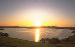
Camperdown lies within the 'Lakes and Craters' region, sitting at the foot of Mount Leura which together with nearby Mount Sugarloaf are part of a large extinct volcanic complex known as the "Leura Maar".[10] To the immediate west are the deep volcanic crater lakes Bullen-Merri and Gnotuk while to the east is the crater lake Purrumbete popular for its Trout and Chinook Salmon fishing.
It is the starting point of the Crater to Coast Rail Trail which, when completed, will reach Port Campbell. It currently terminates in Timboon.
Features
The town is renowned for its classic historical buildings. Central is the 103-foot (31 m) high Gothic Manifold Clock Tower, built 1897, which sits in a wide Elm lined median between the dual carriageways of Manifold Street, named in honour of one of the pioneer pastoralists. Tower, avenue, Boer War memorial, Soldiers' memorial, memorial cross and JC Manifold statue are all listed on the Victorian Heritage Register.
Among the many other classic buildings are the 1886-7 two storey Georgian style Court House, the 1863 two storey bluestone (granite) Post Office, Theatre Royal (1890) and Masonic Hall (1867–68).
The town has a life-sized statue of the Scottish poet Robert Burns, carved from sandstone in the 1830s and based on the earliest painting of the Bard.[11] Efforts to restore the statue led to a festival celebrating the town's connection with Burns being held in 2012 and then annually.[12]
Local government
Originally, Camperdown was part of the East Riding of the Shire of Hampden, which was incorporated in 1857. On 9 September 1952, Camperdown severed and incorporated as a separate borough. It became a town on 21 January 1959.[13] See Town of Camperdown.
On 23 September 1994, the Town was abolished, and merged with Shire of Hampden, most of Shire of Heytesbury and parts of Colac, Mortlake and the area around Princetown on the Great Ocean Road into the Shire of Corangamite.[14]
The Town of Camperdown was not subdivided into wards, and the nine councillors represented the entire area.
Transport
Camperdown is situated on the Princes Highway (A1), which is the main through road and also the main street (Manifold Street). A dual carriageway with a large central reservation and secondary service street runs through the centre of town. The highway runs west to Terang and beyond to Warrnambool and east to Colac and beyond to Geelong. Secondary roads include the Camperdown-Lismore Road which heads north to Lismore and the Camperdown-Cobden Road (C164) which heads south to Cobden. Just west at Gnotuk is the Darlington Road (C173) which leads north to Darlington.
Road coaches (buses) provide links within Camperdown, to neighbouring towns and nearby cities (mainly V/Line) and these services include Cobden, Timboon, Simpson and the city of Ballarat.
The town's railway station is served by V/Line passenger services on the Warrnambool line linking it to the cities of Warrnambool, Geelong and beyond to Melbourne.
Community
The town has many sporting clubs. Archery, badminton, cricket, cycling, golf, horse riding, lawn bowls, squash and tennis, water skiing and yachting have competitions in and around the town. The Camperdown community is heavily involved in competitive sport with the principal sport being Australian Rules Football. The town has a football team playing in the Hampden Football League.[15]
Camperdown has a horse racing club, the Camperdown Turf Club, which holds one race meetings a year, the Camperdown Cup meeting in January.[16]
Golfers play at the Camperdown Golf Club on Lake Bullen Merri Road.[17]
Notable citizens
- Steve Gilchrist - world renowned mandolin and archtop guitar maker
- Norm Sharp - Geelong Premiership player 1952
- Cameron Rahles-Rahbula - four-time Paralympian
- Paul Broderick - Fitzroy and Richmond footballer
- Scott Lucas - Essendon premiership player 2000
- Dean Brebner - National Basketball League
- Ross Thornton - Fitzroy footballer
- Sir Chester Manifold - First Chairman TAB 1961–68 [18]
- Adam Coote - AFL Boundary Umpire
- Len White - Geelong footballer
- Todd Spehr - American college basketball player and author
- Sandy Aasha Carter - Model - 1972 - 1985
- Geoffrey Wickham AO cardiac pacemaker pioneer
- Bill Roycroft - Olympian
- Sarah Wall - ANZ Championship Netball bench warmer, Melbourne Vixens (2009, 2011); Queensland Firebirds (2010)
- Brydon Coverdale - one of the "Chasers" on The Chase Australia[19]
- Easton Wood - Australian rules footballer for Western Bulldogs (2008–Present)
References
- ↑ Australian Bureau of Statistics (27 June 2017). "Camperdown (Vic.) (State Suburb)". 2016 Census QuickStats. Retrieved 29 January 2018.

- ↑ Butler, S., ed. (2009). "Camperdown". Macquarie Dictionary (5th ed.). Sydney: Macquarie Dictionary Publishers Pty Ltd. ISBN 978-1-876429-66-9.
- ↑ Australian Bureau of Statistics (31 October 2012). "Camperdown (Urban Centre/Locality)". 2011 Census QuickStats. Retrieved 2007-10-01.
- ↑ Terang and District Pioneer Register Pre. 1900, 1996, p53
- ↑ Bulbeck, Chilla (April 1991). "Aborigines, memorials and the history of the frontier". Australian Historical Studies. Taylor and Francis. 25 (96): 168–178. doi:10.1080/10314619108595878.
- ↑ Broome, Richard (2005), "Transformations: 1850–1886: 'a miserable spadeful of ground'", in Broome, Richard, Aboriginal Victorians: a history since 1800, Crows Nest, New South Wales: Allen & Unwin, ISBN 978-1-74114-569-4.
- ↑ Gatewaybbs, Camperdown Attractions, retrieved 21 July 2008
- ↑ Premier Postal History, Post Office List, retrieved 11 April 2008
- ↑ Sid Brown (March 1990), "Tracks Across the State", Newsrail, Australian Railway Historical Society (Victorian Division), pp. 71–76.
- ↑ Department of Primary Industry, Corangamite, retrieved 2008-07-21
- ↑ "Victorian Heritage Database. Robert Burns Statue". vhd.heritagecouncil.vic.gov.au. Retrieved 15 April 2018.
- ↑ "About the festival and the Burns Statue". www.camperdownburnsfestival.com.au. Retrieved 15 April 2018.
- ↑ Victorian Municipal Directory, Brunswick: Arnall & Jackson, 1992, p. 542 Accessed at State Library of Victoria, La Trobe Reading Room.
- ↑ Australian Bureau of Statistics (1 August 1995), Victorian local government amalgamations 1994–1995: Changes to the Australian Standard Geographical Classification (PDF), Commonwealth of Australia, p. 5, ISBN 0-642-23117-6, retrieved 2008-01-05
- ↑ Full Point Footy, Camperdown, archived from the original on 7 September 2008, retrieved 2008-07-25
- ↑ Country Racing Victoria, Camperdown Turf Club, archived from the original on 3 August 2008, retrieved 2009-05-07
- ↑ Golf Select, Camperdown, retrieved 2009-05-11
- ↑ http://www.horsedirectory.com.au/racinghistory/general/racing_personalities.html
- ↑ "Brydon on Channel 7's The Chase". Camperdown Chronicle. 14 September 2015. Retrieved 2 October 2015.
External links
![]()
- Camperdown - Official state government tourism organization
- Australian Places - Camperdown
- Corangamite Shire (local government) - Camperdown