Campbell Islands
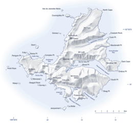 Map of the Campbell Islands | |
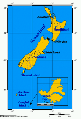 Location relative to New Zealand and other outlying islands | |
| Geography | |
|---|---|
| Area | 113.3 km2 (43.7 sq mi) |
| Highest elevation | 569 m (1,867 ft) |
| Highest point | Mount Honey |
| Administration | |
|
New Zealand | |
| Demographics | |
| Population | Uninhabited |
The Campbell Islands (or Campbell Island group) are a group of subantarctic islands, belonging to New Zealand. They lie about 600 km south of Stewart Island. The islands have a total area of 113.31 km2 (43.75 sq mi), consisting of one big island, Campbell Island (112.68 km2 or 43.51 sq mi), and several small islets, notably Dent Island (0.23 km2 or 0.089 sq mi), Isle de Jeanette Marie (0.11 km2 or 0.042 sq mi, Folly Island (or Folly Islands), Jacquemart Island (0.19 km2 or 0.073 sq mi), and Monowai Island (also known as Lion Rock, 0.08 km2 or 0.031 sq mi).[1] Ecologically, they are part of the Antipodes Subantarctic Islands tundra ecoregion. The islands are one of five subantarctic island groups collectively designated as a World Heritage Site by UNESCO.[2]
Important Bird Area
The Campbell Islands have been identified as an Important Bird Area (IBA) by BirdLife International because of its significance as a breeding site for several species of seabirds as well as the endemic Campbell teal and Campbell snipe. The seabirds are southern rockhopper and yellow-eyed penguins, Antipodean, southern royal, light-mantled, black-browed, Campbell and grey-headed albatrosses, northern giant and white-chinned petrels, and the Campbell shag.[3]
Geography
- Campbell Island (52°32.4′S 169°8.7′E / 52.5400°S 169.1450°E)
- Dent Island (52°31.15′S 169°3.75′E / 52.51917°S 169.06250°E)
- Jacquemart Island (52°37′S 169°7.5′E / 52.617°S 169.1250°E)
- Folly Island or Folly Islands
The islands are relatively flat; due to tectonic pressure, however, there are mountains in the centre of each island. A sea stack at the southern tip of Jacquemart Island is – with the exception of the country's Antarctic claims – New Zealand's southernmost point.
See also
References
- ↑ Archived 16 October 2008 at the Wayback Machine.
- ↑ New Zealand Subantarctic Islands – UNESCO World Heritage Centre
- ↑ BirdLife International. (2012). Important Bird Areas factsheet: Campbell Island (and outliers). Downloaded from "Archived copy". Archived from the original on 10 July 2007. Retrieved 31 August 2013. on 22 January 2012.
External links
- Map of the Campbell Islands with several surrounding islets, including Jacquemart Island lying south of the main island and Dent island lying northwest of the main island