California State Route 96
| ||||
|---|---|---|---|---|
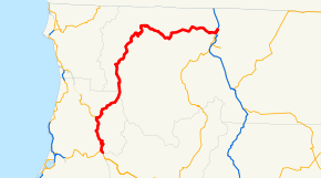 SR 96 highlighted in red | ||||
| Route information | ||||
| Defined by Streets and Highways Code § 396 | ||||
| Maintained by Caltrans | ||||
| Length | 146.519 mi[1] (235.799 km) | |||
| Major junctions | ||||
| West end |
| |||
| East end |
| |||
| Location | ||||
| Counties | Humboldt, Siskiyou | |||
| Highway system | ||||
| ||||

State Route 96 (SR 96) follows the Trinity and Klamath Rivers in Northern California. For most of the route it goes through the Karuk Tribal Reservation, the Yurok Tribal Reservation, and the Hoopa Tribal Reservation. Over half of the length is the Bigfoot Scenic Byway, passing through "the region boasting the most sightings of Bigfoot of anywhere in the country" according to the National Forest Scenic Byway Program.[2]
Route description
The route begins at a junction with State Route 299, the Trinity Highway, in Willow Creek. It heads north, following the Trinity River downstream through Hoopa, and exiting the Trinity National Forest near its confluence with the Klamath River at Weitchpec. At Weitchpec, the route intersects State Route 169 and turns northeast into the Six Rivers National Forest. The highway passes through Orleans and turns more northerly after intersecting Salmon River Road. Passing through Happy Camp, SR 96 enters the Klamath National Forest. After passing through Gottsville, the route exits the national forest. It intersects State Route 263, which heads south toward Yreka. Picking up the designation of Interstate 5 Business, SR 96 turns north. Passing the Randolf Collier Safety Roadside Rest Area, the route meets its terminus at Interstate 5.[3]
SR 96 is not part of the National Highway System,[4] a network of highways that are considered essential to the country's economy, defense, and mobility by the Federal Highway Administration.[5] SR 96 is eligible for the State Scenic Highway System,[6] but it is not officially designated as a scenic highway by the California Department of Transportation.[7]
Major intersections
Except where prefixed with a letter, postmiles were measured on the road as it was in 1964, based on the alignment that existed at the time, and do not necessarily reflect current mileage. R reflects a realignment in the route since then, M indicates a second realignment, L refers an overlap due to a correction or change, and T indicates postmiles classified as temporary (for a full list of prefixes, see the list of postmile definitions).[1] Segments that remain unconstructed or have been relinquished to local control may be omitted. The numbers reset at county lines; the start and end postmiles in each county are given in the county column.
| County | Location | Postmile [1][8][9] | Destinations | Notes | |
|---|---|---|---|---|---|
| Humboldt HUM 0.00-R44.98 | Willow Creek | 0.00 | West end of SR 96 | ||
| Weitchpec | 23.09 | ||||
| Siskiyou SIS R0.00-105.82 | Happy Camp | 41.10 | Main Street | ||
| | 71.33 | Scott River Road – Scott Bar, Fort Jones | |||
| | 103.41 | West end of I-5 Bus. overlap | |||
| | 105.82 | Interchange; east end of I-5 Bus. overlap; east end of SR 96; I-5 exit 786 | |||
1.000 mi = 1.609 km; 1.000 km = 0.621 mi
| |||||
See also

References
- 1 2 3 California Department of Transportation. "State Truck Route List". Sacramento: California Department of Transportation. Archived from the original (XLS file) on June 30, 2015. Retrieved June 30, 2015.
- ↑ National Scenic Byways Online, Bigfoot Scenic Byway, accessed February 2008
- ↑ Google (April 10, 2011). "SR 96" (Map). Google Maps. Google. Retrieved April 10, 2011.
- ↑ Federal Highway Administration (March 25, 2015). National Highway System: California (North) (PDF) (Map). Scale not given. Washington, DC: Federal Highway Administration. Retrieved September 7, 2017.
- ↑ Natzke, Stefan; Neathery, Mike & Adderly, Kevin (June 20, 2012). "What is the National Highway System?". National Highway System. Washington, DC: Federal Highway Administration. Retrieved July 1, 2012.
- ↑ California State Legislature. "Section 260–284". Streets and Highways Code. Sacramento: California State Legislature. Retrieved June 9, 2017.
- ↑ California Department of Transportation (September 7, 2011). "Officially Designated State Scenic Highways and Historic Parkways". Sacramento: California Department of Transportation. Retrieved October 7, 2017.
- ↑ California Department of Transportation (July 2007). "Log of Bridges on State Highways". Sacramento: California Department of Transportation.
- ↑ California Department of Transportation, All Traffic Volumes on CSHS, 2005 and 2006
External links
Route map:
| Wikimedia Commons has media related to California State Route 96. |