California State Route 37
| ||||
|---|---|---|---|---|
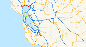 SR 37 highlighted in red | ||||
| Route information | ||||
| Defined by Streets and Highways Code § 337 | ||||
| Maintained by Caltrans | ||||
| Length | 21.494 mi[1] (34.591 km) | |||
| Existed |
1917[2] 1934 – present | |||
| Major junctions | ||||
| West end |
| |||
| ||||
| East end |
| |||
| Location | ||||
| Counties | Marin, Sonoma, Solano | |||
| Highway system | ||||
| ||||

State Route 37 (SR 37) is a state highway in the northern part of California that runs 21 miles (34 km) along the northern shore of San Pablo Bay. It is built from U.S. Route 101 in Novato and runs through the southern tip of Sonoma and Solano Counties to Interstate 80 in Vallejo not through Napa County, on 37 the county line sign says Sonoma on one side of the highway and Solano on the other side. It serves as a vital connection between the four counties of the North Bay Area, north of San Francisco; Sonoma Raceway and Six Flags Discovery Kingdom are accessible from Route 37.
Route 37 has been proposed to be built to freeway standards since the early 1950s. However, the proposal was met with many economic and environmental obstacles, making the task all but impossible for much of the route. Problems included a levee break in Vallejo which turned part of the land around the highway into a marsh that is home to endangered salt marsh harvest mice, and a section of highway known as "Blood Alley" for its high rate of fatal accidents.
Route description

Intended to run from State Route 251, a highway that has not been constructed, SR 37 begins in Novato with a junction at U.S. Route 101 and heads northeast as a freeway for about a quarter mile before becoming a four-lane expressway. The route passes over the Petaluma River into Sonoma County before meeting the southern terminus of State Route 121 at a signal-controlled intersection near Sears Point and the Sonoma Raceway.
The route continues as a divided two-lane expressway in a more easterly, then southeasterly, direction as it crosses Tolay Creek and proceeds through the Napa Sonoma Marsh at the northern edge of San Pablo Bay. Before the construction of the barrier in 1995, this portion of SR 37 was three lanes with the middle lane alternately serving as a passing lane for each direction. This stretch of highway was given the nickname of "Blood Alley" for its high-rate of fatal accidents. With the middle lane removed, accidents dropped dramatically.[3]
SR 37 becomes a four-lane freeway on Mare Island, approaching northern Vallejo. After it crosses over the Napa River Bridge, it continues as a freeway, overlapping the old highway alignment and passing north of the old road known as Marine World Parkway (due to its proximity to the Six Flags Discovery Kingdom, previously known as Marine World). SR 37 travels in a northeasterly direction along the White Slough before turning east as it crosses over State Route 29 and heads to its eastern terminus at I-80 as the James Capoot Memorial Highway (honoring a Vallejo police officer who was killed in the line of duty).[4] In the early 1990s, the stretch between Fairgrounds Drive, which serves as the entrance to Discovery Kingdom, and Mini Drive was upgraded to a freeway. In 2004 and 2005, following over fifty years of complications, the remaining non-freeway section in Vallejo was upgraded as well.[5][6][7]
SR 37 is also known as Randy Bolt Memorial Highway from SR 29 to Skaggs Road (honoring a California Department of Justice agent who was killed in the line of duty in an accident along SR 37), and Sears Point Toll Road, which was originally a toll road that ran from SR 121 to Vallejo.[8] SR 37 is part of the California Freeway and Expressway System,[9] but is not part of the National Highway System,[10] a network of highways that are considered essential to the country's economy, defense, and mobility by the Federal Highway Administration.[11] SR 37 is eligible for the State Scenic Highway System,[12] but it is not officially designated as a scenic highway by the California Department of Transportation.[13]
History
The stretch of road east of Sears Point was once part of the historical El Camino Real.[14] As a result of the State Highways Acts of the early 20th century, the Black Point Cut-off was built over it and opened to traffic in 1917.[2] This highway followed the current alignment east of Sears Point, before diverting northeast along present-day Route 121. It was first designated Legislative Route 8 (LRN 8), later being signed as State Route 37.[15][16]
Prior to being under State control, the section between Sears Point and Vallejo was known as the Sears Point Toll Road, a toll road managed by Golden Gate Ferry[17] that was built over an ancient Native American trail. When it was purchased by the State in 1938, tolls were removed;[3] it then became signed as State Route 48 until 1964.[16]
Route 37 was redefined in the 1964 state highway renumbering as a route starting at SR 251, then SR 17,[18] near Nicasio and ending at I-80 near Lake Chabot.[19] The whole of SR 37 has been proposed to be built to freeway standards since the early 1950s. However, the proposal was met with many economic and environmental obstacles, making the task all but impossible for much of the route.
Sears Point Toll Road
As late as 1926, Golden Gate Ferries, owners of the Sears Point Toll Road Co., began plans to build the Sears Point Toll Road,[17] with a contract awarded to Oakland-based Hutchinson Company in October 1927.[20] The paved toll road was to be built on top of an ancient Native American trail[3] along the San Pablo Bay shore between the Sacramento Highway and the Black Point cut-off (LRN 8) near Sears Point. It was expected to cost $775,000USD, with a toll not exceeding $0.35. Toll road officials explained the purpose of the road; to stimulate motor vehicle usage by reducing the commute times and expenses of motorists traveling from the East Bay and Sacramento areas by offering a more direct route toward Marin, Sonoma and the Redwood Highway.[20] The road opened for traffic in 1928.[3]
On November 29, 1932, the California State Highway Commission received a recommendation to purchase the road[21] and was able to invest $418,000USD by 1936. However, the U.S. Navy owned rights to the right-of-way of part of the route, and opposed the purchase. This resulted in congressional actions to establish a clear title deed for the route.[22][23] House Representative Richard J. Welch was one of the earliest government officials to pressure the State of California to acquire the toll road in order to convert it into a toll-free highway. He argued that having only one toll road to travel in order to reach the Golden Gate Bridge would benefit commuters; he also cited the ten and seventh-tenths-mile difference in distance between the toll road and a route through Napa.[24] A Navy Department deed permitting the State to purchase the road was granted by the Attorney General on October 26, 1938.[25] The highway then became signed as State Route 48 until the 1964 renumbering.[16]
Highway upgrading in Vallejo
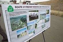
By 1955, talks began about upgrading the highway.[3] After a proposition to turn much of the route into a toll road failed, it was decided a four-lane freeway would be the best decision. However, opposition from residents in surrounding neighborhoods as well as a federal oil embargo only allowed widening of the approach between Fairgrounds Drive and I-80. In 1977, a levee broke and flooded a portion of the developed land, turning it into protected wetlands that is home to endangered species. Because of its new status, environmental studies were needed in order to continue the project.[7]
Soon after, the project was split into different phases[5] to handle problems with particular areas. It was first divided between the newly created marshlands and the section between Sonoma Blvd. (SR 29) and I-80. With Marine World being relocated, the city was able to the widen the latter section and build an overpass across Fairgrounds Drive in 1992.[7]
"Blood Alley"
While the Vallejo section of SR 37 was being updated, another problem with the route would hinder its progress. The section between Sears Point and Mare Island was plagued with fatal accidents, earning its nickname of "Blood Alley". Between 1966 and 1970, 27 people lost their lives to it. In a preliminary effort to reduce the fatalities, officials established both a daylight test section, requiring all cars to keep their headlights on during the day, and passing lanes. However, these efforts were ineffective.[26]
In 1993, local resident Jim Poulos campaigned to have a barrier erected after the death of his 18-year-old son, Frankie, on "Blood Alley". At this time, the situation with this stretch only worsened as the death toll between 1990 and 1996 rose to thirty-one. At first, Caltrans thought the barrier would make matters worse since it would be difficult for emergency vehicles to attend to accidents; environmental issues were also cited. Caltrans was waiting for the ability to create a causeway to span the area instead. Poulos continued his campaign despite opposition, and was granted the barrier in 1995. The barrier was not built without controversy, as it also eliminated the passing lanes. However, since the barriers were built, there were no longer any crossover accidents as of 2005.[3]
While the median was built, a few problems needed to be resolved in order for the road to work both safely and in an environmentally friendly way. Emergency personnel needed to quickly access accidents and provide them easy transport to nearby hospitals. To alleviate this problem, Caltrans implemented electric gate technology, which would allow emergency vehicles to cut through certain parts of the median. The other problem was to both protect the plant life and the salt marsh harvest mice residing around the highway. As a result, crews placed timbers and sheeting to protect foliage, and added holes into the median barrier to allow the mice to cross the highway.[27]
White Slough and Sonoma Boulevard interchange
To protect White Slough while still allowing the widening of SR 37, the White Slough Protection and Development Act was passed in 1990.[28] It allowed up to 13 acres of wetlands to be filled but required at least four times as much wetland restoration elsewhere in the Bay Area.[28]
After environmental studies on the White Slough, Caltrans widened and elevated that section of the road and converted it to a freeway. To accommodate bicycles and pedestrians, a cycleway was built along the eastbound side of the freeway. Finally, Caltrans completed the overpass which crossed SR 29, Broadway, and Mini Drive (bypassing Marine World Parkway, three traffic signaled intersections, and a railroad grade crossing). The project was completed in the summer of 2005,[7] and fully open to traffic on August 20.[29]
Future
It is estimated that improvements along the corridor will be fully funded by 2088.[30]
Major intersections
Except where prefixed with a letter, postmiles were measured on the road as it was in 1964, based on the alignment that existed at the time, and do not necessarily reflect current mileage. R reflects a realignment in the route since then, M indicates a second realignment, L refers an overlap due to a correction or change, and T indicates postmiles classified as temporary (for a full list of prefixes, see the list of postmile definitions).[1] Segments that remain unconstructed or have been relinquished to local control may be omitted. The numbers reset at county lines; the start and end postmiles in each county are given in the county column.
| County | Location | Postmile [1][31][32] | Exit[33] | Destinations | Notes | |
|---|---|---|---|---|---|---|
| Marin MRN R11.20-14.62 | Novato | R11.20 | South Novato Boulevard | Continuation beyond US 101 | ||
| West end of SR 37; US 101 north exit 460A, south exit 460 | ||||||
| 11.50 | Marsh Drive, Hanna Ranch Road | |||||
| East end of freeway | ||||||
| | 13.77 | Atherton Avenue – Black Point | Interchange | |||
| | 14.47 | Harbor Drive | Interchange; no eastbound exit | |||
| Sonoma SON 0.00-R6.25 | | 2.06 | Lakeville Road | |||
| Sears Point | 3.90 | Serves Sonoma Raceway | ||||
| Solano SOL R0.00-R12.00 | | West end of freeway | ||||
| Vallejo | R7.21 | 17 | Walnut Avenue – Mare Island | |||
| R7.39 | Mare Island Bridge over Napa River | |||||
| 8.01 | 18 | Wilson Avenue, Sacramento Street | ||||
| 9.52 | 19 | |||||
| 10.96 | 20 | Fairgrounds Drive – Discovery Kingdom | ||||
| R12.00 | 21 | Eastbound exit and westbound entrance; signed as exits 21A (west) and 21C (east); I-80 east exit 33, west exit 33B | ||||
| 21B | Auto Mall Columbus Parkway | Eastbound exit and westbound entrance; east end of SR 37 | ||||
| 1.000 mi = 1.609 km; 1.000 km = 0.621 mi | ||||||
Popular culture
The route is used as the title for Train's 2012 album California 37. The album cover includes a picture of the spade California 37 sign, but is not actually a picture of the highway.
See also

References
- 1 2 3 California Department of Transportation. "State Truck Route List". Sacramento: California Department of Transportation. Archived from the original (XLS file) on June 30, 2015. Retrieved June 30, 2015.
- 1 2 LeBaron, Gaye (September 10, 1995). "The Damp and Difficult History of Highway 37". Santa Rosa Press Democrat. p. A2.
Some of Marin's problem was solved in 1917 with the opening of the Black Point Cut-Off, a straight-on stretch of roadway bordering the tidelands from Ignacio on the San Rafael to Santa Rosa north-south road to the little town of Black Point on the Sonoma–Marin county line, connecting with Route 8, (now Highway 121) the road from Napa by way of Schellville, which had been taken into the state system in 1909.
- 1 2 3 4 5 6 Gafni, Matthias. "'Blood Alley' Dad's crusade curbs carnage". Vallejo Times Herald. ANG Newspapers. Archived from the original on November 21, 2006. Retrieved April 21, 2013.
- ↑ "Portion of Highway 37 to be named after Jim Capoot". Vallejo Times Herald. 1 September 2013. Retrieved 10 January 2014.
- 1 2 "Caltrans Route 37 Improvements". Archived from the original on February 20, 2007. Retrieved March 2, 2007.
- ↑ "Route 37 Freeway Draft Environmental Impact Statement". California Department of Transportation. Archived from the original on October 2, 2006. Retrieved March 2, 2007.
- 1 2 3 4 Gafni, Matthias. "'Perserverance'[sic] at a high price". Vallejo Times Herald. ANG Newspapers. Archived from the original on November 21, 2006. Retrieved September 24, 2009.
- ↑ California Department of Transportation; California State Transportation Agency (January 2015). 2014 Named Freeways, Highways, Structures and Other Appurtenances in California. Sacramento: California Department of Transportation. pp. 49, 210, 275. Archived from the original (PDF) on May 30, 2015. Retrieved May 30, 2015.
- ↑ California State Legislature. "Section 250–257". Streets and Highways Code. Sacramento: California State Legislature. Retrieved June 9, 2017.
- ↑ Federal Highway Administration (March 25, 2015). National Highway System: California (North) (PDF) (Map). Scale not given. Washington, DC: Federal Highway Administration. Retrieved October 15, 2017.
Federal Highway Administration (March 25, 2015). National Highway System: Vallejo, CA (PDF) (Map). Scale not given. Washington, DC: Federal Highway Administration. Retrieved October 15, 2017. - ↑ Natzke, Stefan; Neathery, Mike & Adderly, Kevin (June 20, 2012). "What is the National Highway System?". National Highway System. Washington, DC: Federal Highway Administration. Retrieved July 1, 2012.
- ↑ California State Legislature. "Section 260–284". Streets and Highways Code. Sacramento: California State Legislature. Retrieved June 9, 2017.
- ↑ California Department of Transportation (September 7, 2011). "Officially Designated State Scenic Highways and Historic Parkways". Sacramento: California Department of Transportation. Retrieved October 15, 2017.
- ↑ California Streets and Highways Code, Chapter 2, Article 3, Section 635
- ↑ Road Map of California 1936 (Map). Cartography by Highways Division. State of California Department of Public Works.
- 1 2 3 Road Map of California 1956 (Map). Cartography by Highways Division. State of California Department of Public Works.
- 1 2 "Golden Gate Ferries, Inc". Berkeley Daily Gazette. October 1, 1927. Retrieved April 22, 2013.
- ↑ California State Assembly. "An act...relating to state highways". 1983–1984 Session of the Legislature. Statutes of California. State of California. Ch. 409.
- ↑ California State Assembly. "An act to add Section 253 and Article 3 (commencing with Section 300) to Chapter 2 of Division 1 of, and to repeal Section 253 and Article 3 (commencing with Section 300) of Chapter 2 of Division 1 of, the..." 1963 Session of the Legislature. Statutes of California. State of California. Ch. 385 p. 1182.
- 1 2 "Award Contract on Sears Point Cut-off". Berkeley Daily Gazette. October 1, 1926. Retrieved April 22, 2013.
- ↑ "Ask Showdown on Sears Point Road". Berkeley Daily Gazette. United Press International. November 29, 1932. Retrieved April 22, 2013.
- ↑ "Sears Point Road Status Undecided". Berkeley Daily Press. United Press International. June 17, 1936. Retrieved April 23, 2013.
- ↑ "Sears Point Road Acquisition Aided". Berkeley Daily Gazette. United Press International. October 14, 1938. Retrieved April 23, 2013.
- ↑ "Ask Showdown on Sears Point Road". Berkeley Daily Gazette. United Press International. September 14, 1936. Retrieved April 22, 2013.
- ↑ "Approves Toll Road Purchase". Berkeley Daily Press. United Press International. October 25, 1938. Retrieved April 23, 2013.
- ↑ "'Experimental idea: Daylight Headlight Test fails to return the expected results". Vallejo Times Herald. ANG Newspapers. Archived from the original on November 21, 2006. Retrieved April 21, 2013.
- ↑ "Crews improvise to erect Highway 37 median". Vallejo Times Herald. ANG Newspapers. Archived from the original on November 21, 2006. Retrieved April 21, 2015.
- 1 2 "California Government Code Section 66670-66682". Retrieved April 2, 2013.
- ↑ Cobb, Steve (August 14, 2005). "Route 37 Traffic Switch onto New Alignment Starts Tonight in Vallejo" (PDF) (Press release). California Department of Transportation. Retrieved January 11, 2008.
- ↑ Richards, Gary (24 May 2017). "Roadshow: Delay in highway fix estimated at … 71 years?". The Mercury News. Retrieved 24 May 2017.
- ↑ California Department of Transportation (July 2007). "Log of Bridges on State Highways". Sacramento: California Department of Transportation.
- ↑ Staff (2005–2006). "All Traffic Volumes on CSHS". California Department of Transportation.
- ↑ Warring, KS. "Route 37" (PDF). California Numbered Exit Uniform System. California Department of Transportation. Retrieved 4 February 2008.
External links
| Wikimedia Commons has media related to California State Route 37. |
Route map: