California State Route 225
| ||||
|---|---|---|---|---|
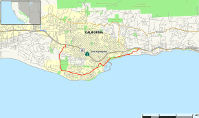 Map of Santa Barbara County in southern California with former SR 225 highlighted in red | ||||
| Route information | ||||
| Maintained by Caltrans | ||||
| Length | 4.643 mi[1] (7.472 km) | |||
| Existed | 1963 – 2014 | |||
| Major junctions | ||||
| West end |
| |||
| East end |
| |||
| Location | ||||
| Counties | Santa Barbara | |||
| Highway system | ||||
| ||||

State Route 225 (SR 225) was a state highway in the U.S. state of California.
Route description
SR 225 was a route that closely followed the beaches of the city of Santa Barbara. It started off near the Earl Warren Showgrounds at the junction of U.S. Route 101 and Las Positas Road and headed south towards the coast before turning east on Cliff Drive. It then climbed up a small viaduct before descending near Santa Barbara City College and ended at Castillo Street and US 101.
History
Until 1998, SR 225 followed Cabrillo Boulevard along the beach, ending near Montecito. On January 30, 2014, Caltrans transferred control of SR 225 to the city of Santa Barbara.
Major intersections
Except where prefixed with a letter, postmiles were measured on the road as it was in 1964, based on the alignment that existed at the time, and do not necessarily reflect current mileage. R reflects a realignment in the route since then, M indicates a second realignment, L refers an overlap due to a correction or change, and T indicates postmiles classified as temporary (for a full list of prefixes, see the list of postmile definitions).[1] Segments that remain unconstructed or have been relinquished to local control may be omitted. The entire route is in Santa Barbara, Santa Barbara County.
| Postmile [1][2][3] | Destinations | Notes | |||
|---|---|---|---|---|---|
| 0.00 | Las Positas Road | Continuation beyond US 101 | |||
| 0.00 | Interchange; west end of SR 225 | ||||
| R4.64 | Interchange; east end of SR 225 | ||||
| R4.64 | Castillo Street | Continuation beyond US 101 | |||
| 1.000 mi = 1.609 km; 1.000 km = 0.621 mi | |||||
See also

References
- 1 2 3 California Department of Transportation. "State Truck Route List". Sacramento: California Department of Transportation. Archived from the original (XLS file) on June 30, 2015. Retrieved June 30, 2015.
- ↑ California Department of Transportation (July 2007). "Log of Bridges on State Highways". Sacramento: California Department of Transportation.
- ↑ California Department of Transportation, All Traffic Volumes on CSHS, 2005 and 2006
External links
Route map:
| Wikimedia Commons has media related to California State Route 225. |