Iara, Cluj
| Iara | |
|---|---|
| Commune | |
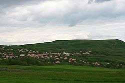 View of the village of Agriș | |
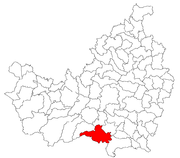 Location in Cluj County | |
 Location on Romania map | |
| Coordinates: 46°33′11″N 23°31′04″E / 46.55306°N 23.51778°ECoordinates: 46°33′11″N 23°31′04″E / 46.55306°N 23.51778°E | |
| Country |
|
| County | Cluj County |
| Status | Commune |
| Settled | 1176 |
| Commune seat | Iara |
| Villages | Agriș, Borzești, Buru, Cacova Ierii, Făgetu Ierii, Iara, Lungești, Măgura Ierii, Mașca, Ocolișel, Surduc, Valea Agrișului, Valea Vadului |
| Government | |
| • Mayor | Ioan Dorin Popa |
| Area | |
| • Total | 143.87 km2 (55.55 sq mi) |
| Elevation | 465 m (1,526 ft) |
| Population (July 1, 2007)[1] | |
| • Total | 4,554 |
| • Density | 32/km2 (82/sq mi) |
| Time zone | UTC+2 (EET) |
| • Summer (DST) | UTC+3 (EEST) |
| Area code(s) | +40 x64[2] |
| Website | http://www.cjcluj.ro/iara/ |
Iara (Hungarian: Alsójára; German: Jahren) is a commune in the southern part of Cluj County, Romania. It is composed of thirteen villages: Agriș (Ruhaegres), Borzești (Berkes), Buru (Borrév), Cacova Ierii (Aranyosivánfalva), Făgetu Ierii (Bikalat), Iara, Lungești (Szurdoklunzsest), Măgura Ierii (Járamagura), Mașca (Macskakő), Ocolișel (Felsőaklos), Surduc (Járaszurdok), Valea Agrișului (Egrespatak) and Valea Vadului (Vádpatak).
Demographics
According to the census from 2002, the total population of the commune was 4,704 people. Of this population, 90.68% were ethnic Romanians, 6.01% ethnic Romani and 3.16% are ethnic Hungarians.[3]
References
- ↑ "Population as of July 1, 2007" (in Romanian). INSSE. April 4, 2008. Archived from the original on August 7, 2010. Retrieved May 4, 2008.
- ↑ x is a digit indicating the operator: 2 for the former national operator, Romtelecom, and 3 for the other ground telephone networks
- ↑ http://www.edrc.ro/recensamant.jsp?regiune_id=2140&judet_id=2295&localitate_id=2338

This article is issued from
Wikipedia.
The text is licensed under Creative Commons - Attribution - Sharealike.
Additional terms may apply for the media files.