Căpușu Mare
| Căpușu Mare Magyarkapus | |
|---|---|
| Commune | |
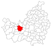 Location in Cluj County | |
 Location on Romania map | |
| Coordinates: 46°47′20″N 23°17′30″E / 46.78889°N 23.29167°ECoordinates: 46°47′20″N 23°17′30″E / 46.78889°N 23.29167°E | |
| Country |
|
| County | Cluj County |
| Status | Commune |
| Settled | 1282 |
| Commune seat | Căpușu Mare |
| Villages | Agârbiciu, Bălcești, Căpușu Mare, Căpușu Mic, Dângău Mare, Dângău Mic, Dumbrava, Păniceni, Straja |
| Government | |
| • Mayor | Iancu Marcel Mocean |
| Area | |
| • Total | 58.4 km2 (22.5 sq mi) |
| Population (July 1, 2007)[1] | |
| • Total | 3,475 |
| • Density | 60/km2 (150/sq mi) |
| Time zone | UTC+2 (EET) |
| • Summer (DST) | UTC+3 (EEST) |
| Area code(s) | +40 x64[2] |
| Website | http://www.cjcluj.ro/capusu-mare/ |
Căpuşu Mare (Hungarian: Magyarkapus; German: Grossthoren) is a commune in Cluj County, Romania, located 27 kilometers west of the city of Cluj-Napoca. It is composed of nine villages: Agârbiciu (Egerbegy), Bălcești (Balkujtelep), Căpușu Mare, Căpușu Mic (Magyarkiskapus), Dângău Mare (Bánffydongó), Dângău Mic (Gyerőfidongó), Dumbrava (Gyerővásárhely), Păniceni (Gyerőfalva) and Straja (Gesztrágy).
Economy
The main industry is an iron ore extraction facility. It is a tourist destination, with many new motels built in recent years.
Demographics
According to the 2011 census, Romanians made up 55.9% of the population, Hungarians made up 38.1% and Roma made up 4.9%.[3]
References
- ↑ "Population as of July 1, 2007" (in Romanian). INSSE. April 4, 2008. Archived from the original on 2010-01-17. Retrieved 2008-05-04.
- ↑ x is a digit indicating the operator: 2 for the former national operator, Romtelecom, and 3 for the other ground telephone networks
- ↑ http://www.cluj.insse.ro/cmscluj/files%5Cdeclaratii%5CComunicat%20CLUJ%20-%20DATE%20PROVIZORII%20RPL%202011.pdf%5Bpermanent+dead+link%5D

This article is issued from
Wikipedia.
The text is licensed under Creative Commons - Attribution - Sharealike.
Additional terms may apply for the media files.