Cache River State Natural Area
| Cache River State Natural Area | |
|---|---|
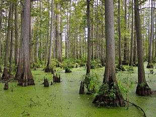 Taxodium distichum in Heron Pond | |
 Map of the U.S. state of Illinois showing the location of Cache River State Natural Area | |
| Location | Johnson County, Illinois, USA |
| Nearest city | Belknap, Illinois |
| Coordinates | 37°21′44″N 88°57′20″W / 37.36222°N 88.95556°WCoordinates: 37°21′44″N 88°57′20″W / 37.36222°N 88.95556°W |
| Area | 14,314 acres (5,793 ha) |
| Established | 1970 |
| Governing body | Illinois Department of Natural Resources |
Cache River State Natural Area is an Illinois state park on 14,314 acres (5,793 ha) in Johnson County, Illinois, United States.
References
- "Cache River State Natural Area". Illinois Department of Natural Resources. Archived from the original on 2007-06-07. Retrieved 2018-07-06.
- USGS. "Cache River State Natural Area, USGS Karnak (IL) Quad". TopoQuest. Retrieved 2008-07-05.
This article is issued from
Wikipedia.
The text is licensed under Creative Commons - Attribution - Sharealike.
Additional terms may apply for the media files.