Căianu
| Căianu Magyarkályán | |
|---|---|
| Commune | |
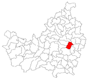 Location in Cluj County | |
 Location on Romania map | |
| Coordinates: 46°47′0″N 23°55′0″E / 46.78333°N 23.91667°ECoordinates: 46°47′0″N 23°55′0″E / 46.78333°N 23.91667°E | |
| Country |
|
| County | Cluj County |
| Status | Commune |
| Settled | 1326 |
| Commune seat | Căianu |
| Villages | Bărăi, Căianu, Căianu Mic, Căianu-Vamă, Vaida-Cămăraș, Văleni |
| Government | |
| • Mayor | Vasile Pop |
| Area | |
| • Total | 55.11 km2 (21.28 sq mi) |
| Population (2011)[1] | |
| • Total | 2,282 |
| • Density | 41/km2 (110/sq mi) |
| Time zone | UTC+2 (EET) |
| • Summer (DST) | UTC+3 (EEST) |
| Area code(s) | +40 x64[2] |
| Website | http://www.cjcluj.ro/caianu/ |
Căianu (Hungarian: Magyarkályán; German: Klandorf) is a commune in Cluj County, Romania. It is composed of six villages: Bărăi (Báré), Căianu, Căianu Mic (Kiskályán), Căianu-Vamă (Kályánivám), Vaida-Cămăraș (Vajdakamarás) and Văleni (Lárgatanya).
Demographics
According to the 2011 census, Romanians made up 59.9% of the population, Hungarians made up 37.4% and Roma made up 2.7%.[1]
References
- 1 2 "Comunicat de presă privind rezultatele provizorii ale Recensământului Populaţiei şi Locuinţelor – 2011" (PDF) (in Romanian). INSSE. February 2, 2012. Retrieved 2012-03-26.
- ↑ x is a digit indicating the operator: 2 for the former national operator, Romtelecom, and 3 for the other ground telephone networks

This article is issued from
Wikipedia.
The text is licensed under Creative Commons - Attribution - Sharealike.
Additional terms may apply for the media files.