Byron, Georgia
| Byron, Georgia | |
|---|---|
| City | |
 Byron Municipal Complex | |
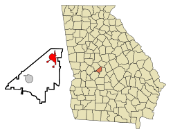 Location in Peach County and the state of Georgia | |
| Coordinates: 32°38′56″N 83°45′20″W / 32.64889°N 83.75556°WCoordinates: 32°38′56″N 83°45′20″W / 32.64889°N 83.75556°W | |
| Country | United States |
| State | Georgia |
| Counties | Peach, Houston |
| Area | |
| • Total | 8.65 sq mi (22.41 km2) |
| • Land | 8.63 sq mi (22.35 km2) |
| • Water | 0.02 sq mi (0.06 km2) |
| Elevation | 509 ft (155 m) |
| Population (2010) | |
| • Total | 4,512 |
| • Estimate (2016)[1] | 5,133 |
| • Density | 523/sq mi (201.9/km2) |
| Time zone | UTC-5 (Eastern (EST)) |
| • Summer (DST) | UTC-4 (EDT) |
| ZIP code | 31008 |
| Area code(s) | 478 |
| FIPS code | 13-12260[2] |
| GNIS feature ID | 0354930[3] |
| Website |
byronga |

Byron is a city located primarily in Peach County, Georgia, United States. A small portion of the city extends into Houston County. The population was 4,512 at the 2010 census,[4] up from 2,887 in 2000. The city is in the Macon metropolitan area.
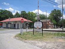
Byron was home to the Middle Georgia Raceway, an auto racetrack that hosted NASCAR races and the filming of TV commercials and a feature movie. From July 3–5, 1970, in a field next to the raceway, the Atlanta International Pop Festival was held, which was the largest gathering in Georgia history until the 1996 Olympics in Atlanta.[5] On September 15, 2012, an official Georgia Historical Society marker was placed near the raceway site to commemorate the festival.[6]
History
The community was named after Lord Byron, the British Romantic poet.[7] A former variant name was "Jackson", but the name was changed in order to avoid repetition with the Jackson in Butts County.[8] The Georgia General Assembly incorporated the place as the "Town of Byron" in 1874.[9]
Geography
Byron is located in the northeast corner of Peach County at 32°38′56″N 83°45′20″W / 32.64889°N 83.75556°W (32.648908, -83.755640),[10] near the geographic center of Georgia. Interstate 75 passes through the eastern side of the city, with access from Exits 146 and 149 (Georgia State Route 49). Byron is 93 miles (150 km) south of Atlanta, 16 miles (26 km) south of Macon, and 11 miles (18 km) northeast of the Peach County seat of Fort Valley.
According to the United States Census Bureau, the city has a total area of 8.6 square miles (22.4 km2), of which 0.02 square miles (0.06 km2), or 0.28%, are water.[4]
Demographics
| Historical population | |||
|---|---|---|---|
| Census | Pop. | %± | |
| 1880 | 137 | — | |
| 1930 | 318 | — | |
| 1940 | 305 | −4.1% | |
| 1950 | 379 | 24.3% | |
| 1960 | 1,138 | 200.3% | |
| 1970 | 1,368 | 20.2% | |
| 1980 | 1,661 | 21.4% | |
| 1990 | 2,276 | 37.0% | |
| 2000 | 2,887 | 26.8% | |
| 2010 | 4,512 | 56.3% | |
| Est. 2016 | 5,133 | [1] | 13.8% |
| U.S. Decennial Census[11] | |||
As of the census[2] of 2000, there were 2,887 people, 1,061 households, and 829 families residing in the city. The population density was 495.7 people per square mile (191.5/km²). There were 1,177 housing units at an average density of 202.1 per square mile (78.1/km²). The racial makeup of the city was 76.69% White, 20.23% African American, 0.38% Native American, 0.52% Asian, 0.10% Pacific Islander, 0.55% from other races, and 1.52% from two or more races. Hispanic or Latino of any race were 0.83% of the population.
There were 1,061 households out of which 38.5% had children under the age of 18 living with them, 59.8% were married couples living together, 14.7% had a female householder with no husband present, and 21.8% were non-families. 18.4% of all households were made up of individuals and 7.8% had someone living alone who was 65 years of age or older. The average household size was 2.72 and the average family size was 3.09.
In the city, the population was spread out with 28.6% under the age of 18, 7.7% from 18 to 24, 31.6% from 25 to 44, 23.1% from 45 to 64, and 9.1% who were 65 years of age or older. The median age was 34 years. For every 100 females, there were 92.9 males. For every 100 females age 18 and over, there were 85.3 males.
The median income for a household in the city was $45,691, and the median income for a family was $51,051. Males had a median income of $36,134 versus $26,250 for females. The per capita income for the city was $18,811. About 8.5% of families and 11.5% of the population were below the poverty line, including 14.0% of those under age 18 and 16.2% of those age 65 or over.
Arts and culture
Thc city hosts the Battle of Byron, an annual charity fundraiser.[12]
References
- 1 2 "Population and Housing Unit Estimates". Retrieved June 9, 2017.
- 1 2 "American FactFinder". United States Census Bureau. Archived from the original on 2013-09-11. Retrieved 2008-01-31.
- ↑ "US Board on Geographic Names". United States Geological Survey. 2007-10-25. Retrieved 2008-01-31.
- 1 2 "Geographic Identifiers: 2010 Demographic Profile Data (G001): Byron city, Georgia". American Factfinder. U.S. Census Bureau. Retrieved May 18, 2017.
- ↑
- ↑ Kulkosky, Victor. (2012-09-19). "Byron Pop Festival Gets Historic Marker". The Leader Tribune, Peach County, GA.
- ↑ "Peach County". New Georgia Encyclopedia. Retrieved 4 April 2018.
- ↑ Krakow, Kenneth K. (1975). Georgia Place-Names: Their History and Origins (PDF). Macon, GA: Winship Press. p. 30. ISBN 0-915430-00-2.
- ↑ Library, New York Public (1912). Bulletin of the New York Public Library. New York Public Library. p. 676.
- ↑ "US Gazetteer files: 2010, 2000, and 1990". United States Census Bureau. 2011-02-12. Retrieved 2011-04-23.
- ↑ "Census of Population and Housing". Census.gov. Archived from the original on May 12, 2015. Retrieved June 4, 2015.
- ↑ "The Battle of Byron". City of Byron. Retrieved 4 April 2018.
External links
Byron Convention & Visitors Bureau
Municipalities and communities of Peach County, Georgia, United States | ||
|---|---|---|
| Cities | 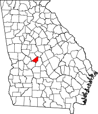 | |
| Unincorporated community | ||
| Footnotes | ‡This populated place also has portions in an adjacent county or counties | |
Municipalities and communities of Houston County, Georgia, United States | ||
|---|---|---|
| Cities |  | |
| CDP | ||
| Unincorporated communities | ||
| Footnotes | ‡This populated place also has portions in an adjacent county or counties | |
| Principal cities | 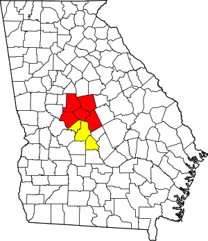 | |
|---|---|---|
| Municipalities | ||
| Other communities | ||
| Counties | ||
| CSA components | ||