Butler Township, Richland County, Ohio
| Butler Township, Richland County, Ohio | |
|---|---|
| Township | |
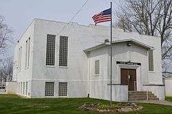 Township hall at Adario | |
 Location of Butler Township in Richland County. | |
| Coordinates: 40°57′2″N 82°27′6″W / 40.95056°N 82.45167°WCoordinates: 40°57′2″N 82°27′6″W / 40.95056°N 82.45167°W | |
| Country | United States |
| State | Ohio |
| County | Richland |
| Area | |
| • Total | 25.5 sq mi (66.1 km2) |
| • Land | 25.5 sq mi (66.1 km2) |
| • Water | 0.0 sq mi (0.0 km2) |
| Elevation[1] | 1,148 ft (350 m) |
| Population (2000) | |
| • Total | 1,386 |
| • Density | 54.3/sq mi (21.0/km2) |
| Time zone | UTC-5 (Eastern (EST)) |
| • Summer (DST) | UTC-4 (EDT) |
| Area code(s) | 419 |
| FIPS code | 39-10646[2] |
| GNIS feature ID | 1086873[1] |
Butler Township is one of the eighteen townships of Richland County, Ohio, United States. It is a part of the Mansfield Metropolitan Statistical Area. The 2000 census found 1,386 people in the township.[3]
Geography
Located in the northeastern corner of the county, it borders the following townships:
- Ruggles Township, Ashland County - northeast
- Clear Creek Township, Ashland County - east
- Milton Township, Ashland County - southeast corner
- Weller Township - south
- Franklin Township - southwest corner
- Blooming Grove Township - west
- Greenwich Township, Huron County - northwest
No municipalities are located in Butler Township.
Name and history
It is one of six Butler Townships statewide.[4]
Government
The township is governed by a three-member board of trustees, who are elected in November of odd-numbered years to a four-year term beginning on the following January 1. Two are elected in the year after the presidential election and one is elected in the year before it. There is also an elected township fiscal officer,[5] who serves a four-year term beginning on April 1 of the year after the election, which is held in November of the year before the presidential election. Vacancies in the fiscal officership or on the board of trustees are filled by the remaining trustees.
References
- 1 2 "US Board on Geographic Names". United States Geological Survey. 2007-10-25. Retrieved 2008-01-31.
- ↑ "American FactFinder". United States Census Bureau. Archived from the original on 2013-09-11. Retrieved 2008-01-31.
- ↑ Richland County, Ohio — Population by Places Estimates Ohio State University, 2007. Accessed 15 May 2007.
- ↑ "Detailed map of Ohio" (PDF). United States Census Bureau. 2000. Retrieved 2007-02-16.
- ↑ §503.24, §505.01, and §507.01 of the Ohio Revised Code. Accessed 4/30/2009.
External links
Municipalities and communities of Richland County, Ohio, United States | ||
|---|---|---|
| Cities | 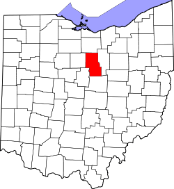 | |
| Villages | ||
| Townships | ||
| Unincorporated communities | ||
| Ghost towns | ||
| Footnotes | ‡This populated place also has portions in an adjacent county or counties | |