Burns Junction, Oregon
| Burns Junction | |
|---|---|
| Unincorporated community | |
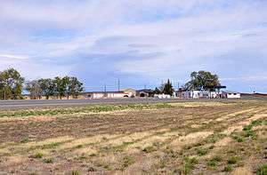 Burns Junction skyline | |
 Burns Junction Location within the state of Oregon  Burns Junction Burns Junction (the US) | |
| Coordinates: 42°46′37″N 117°51′12″W / 42.77694°N 117.85333°WCoordinates: 42°46′37″N 117°51′12″W / 42.77694°N 117.85333°W | |
| Country | United States |
| State | Oregon |
| County | Malheur |
| Elevation | 3,934 ft (1,199 m) |
| Time zone | UTC-7 (Mountain) |
| • Summer (DST) | UTC-6 (MDT) |
| ZIP codes | 97910 |
| Area code(s) | 541 |
| Coordinates and elevation from United States Geological Survey[1] | |
Burns Junction is an unincorporated community in Malheur County, Oregon, United States,[1] at the intersection of U.S. Route 95 and Oregon Route 78, about 80 miles (130 km) southeast of the Harney County city of Burns.[2]
Climate
According to the Köppen Climate Classification system, Burns Junction has a semi-arid climate, abbreviated "BSk" on climate maps.[3]
References
- 1 2 "Burns Junction". Geographic Names Information System. United States Geological Survey. November 28, 1980. Retrieved November 13, 2010.
- ↑ Oregon Atlas & Gazetteer (7th ed.). Yarmouth, Maine: DeLorme. 2008. pp. 82–83, 87. ISBN 0-89933-347-8.
- ↑ "Burns Junction, Oregon". Weatherbase. CantyMedia. Retrieved February 1, 2017.
Municipalities and communities of Malheur County, Oregon, United States | ||
|---|---|---|
| Cities | 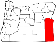 | |
| CDPs | ||
| Other unincorporated communities | ||
| Ghost town | ||
| Indian reservation | ||
| Footnotes | ‡This populated place also has portions in an adjacent county or counties | |
This article is issued from
Wikipedia.
The text is licensed under Creative Commons - Attribution - Sharealike.
Additional terms may apply for the media files.