Annex, Oregon
| Annex, Oregon | |
|---|---|
| Unincorporated community | |
 Annex, Oregon  Annex, Oregon | |
| Coordinates: 44°14′25″N 116°59′04″W / 44.24028°N 116.98444°WCoordinates: 44°14′25″N 116°59′04″W / 44.24028°N 116.98444°W | |
| Country | United States |
| State | Oregon |
| County | Malheur |
| Area[1] | |
| • Total | 2.461 sq mi (6.37 km2) |
| • Land | 2.461 sq mi (6.37 km2) |
| • Water | 0 sq mi (0 km2) |
| Elevation | 2,103 ft (641 m) |
| Population (2010)[1] | |
| • Total | 235 |
| • Density | 95/sq mi (37/km2) |
| Time zone | UTC-7 (Mountain (MST)) |
| • Summer (DST) | UTC-6 (MDT) |
| Area code(s) | 541 & 458 |
| GNIS feature ID | 1129770[2] |
Annex is an unincorporated community and census-designated place in Malheur County, Oregon, United States. Its population was 235 as of the 2010 census.[1] The community is located on the south bank of the Snake River across from Weiser, Idaho; a bridge carrying U.S. Route 95 Spur connects the two.
Geography
According to the U.S. Census Bureau, the community has an area of 2.461 square miles (6.37 km2), all of it land.[1]
References
- 1 2 3 4 "2010 Census Gazetteer Files - Places: Oregon". U.S. Census Bureau. Retrieved January 17, 2017.
- ↑ "Annex". Geographic Names Information System. United States Geological Survey.
Municipalities and communities of Malheur County, Oregon, United States | ||
|---|---|---|
| Cities | 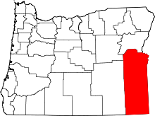 | |
| CDPs | ||
| Other unincorporated communities | ||
| Ghost town | ||
| Indian reservation | ||
| Footnotes | ‡This populated place also has portions in an adjacent county or counties | |
This article is issued from
Wikipedia.
The text is licensed under Creative Commons - Attribution - Sharealike.
Additional terms may apply for the media files.