Burkittsville Historic District
|
Burkittsville | |
 | |
  | |
| Location | MD 17 and Jefferson-Boonsboro Rd., Burkittsville, Maryland |
|---|---|
| Coordinates | 39°23′31″N 77°37′39″W / 39.39194°N 77.62750°WCoordinates: 39°23′31″N 77°37′39″W / 39.39194°N 77.62750°W |
| Area | 300 acres (120 ha) |
| Built | 1790 |
| Architectural style | Late Victorian, Greek Revival, Federal |
| NRHP reference # | 75000891[1] |
| Added to NRHP | November 20, 1975 |
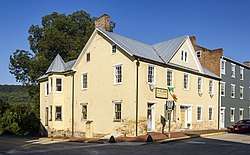
The Burkittsville Historic District comprises the small town of Burkittsville, Maryland. Located at a crossroads in western Frederick County, the town is a consistent collection of early 19th-century Federal style houses mixed with a few Victorian style houses that has remained virtually unchanged since 1900. The town is surrounded on three sides by an open, farmed landscape, and nestles against South Mountain on its western side.[2]
The town was involved in a number of Civil War actions, including the Battle of Crampton's Gap in 1862.
The Burkittsville Historic District was listed on the National Register of Historic Places in 1975.[1]
References
- 1 2 National Park Service (2010-07-09). "National Register Information System". National Register of Historic Places. National Park Service.
- ↑ Lawrence A. Way; Rev. H. Austin Cooper; Walton D. Stowell; Barbara Winslow & Mary Kay Winslow (May 1975). "National Register of Historic Places Registration: Burkittsville Historic District" (PDF). Maryland Historical Trust. Retrieved 2016-01-01.
External links
- Burkittsville Historic District, Frederick County, including 1996 photo, at Maryland Historical Trust
- Boundary Map of the Burkittsville Historic District, Frederick County, at Maryland Historical Trust
| Topics |  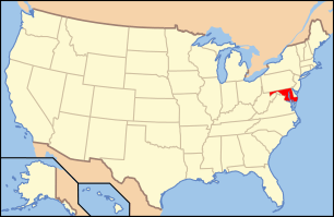 | |
|---|---|---|
| Lists by county | ||
| Lists by city | ||
| Other lists | ||
| ||
This article is issued from
Wikipedia.
The text is licensed under Creative Commons - Attribution - Sharealike.
Additional terms may apply for the media files.