Burgwerd
| Burgwerd Burchwert | |||
|---|---|---|---|
| Village | |||
 | |||
| |||
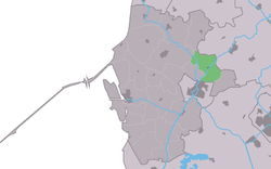 Location in the former Wûnseradiel municipality | |||
 Burgwerd Location in the Netherlands | |||
| Coordinates: Coordinates: 53°5′16″N 5°32′45″E / 53.08778°N 5.54583°E | |||
| Country |
| ||
| Province |
| ||
| Municipality |
| ||
| Population (2017) | |||
| • Total | 315 | ||
| Time zone | UTC+1 (CET) | ||
| • Summer (DST) | UTC+2 (CEST) | ||
| Postal code | 8742 | ||
| Dialing code | 0515 | ||


Burgwerd (West Frisian: Burchwert) is a small village in Súdwest-Fryslân in the province of Friesland, the Netherlands. It had a population of around 315 in January 2017.[1] It is located near the Boalserter Trekfeart.
History
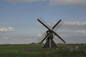
Burgwerd was originally a town on a terp or mound on the Dieperderhimpolder dyke. In the 13th century it was known as Borghwarth. The church dating from the 13th century was made from weatherboard until 1726. There are two windmills in Burgwerd, the Aylvapoldermolen and De Heimerter Mole.
On 21 July 2006 there was a reunion of inhabitants and former residents of Burgwerd. Before 2011, the village was part of the Wûnseradiel municipality.
Population history
- 1954 - 438
- 1959 - 398
- 1964 - 377
- 1969 - 339
- 1973 - 361
- 2004 - 348
Streets
De Opfeart, De Trekfeart, Doniaweg, Hemert, It Klaailân, Kapelstrjitte, Tsjerkhôf, Kleasterwei, Pealdyk, Skoallestrjite, Schwartzenbergwei, Sjungadyk, Trekpaad.
References
- ↑ Kerncijfers wijken en buurten 2017 - CBS Statline
- Lolle Baarda Van Borghwarth tot Burgwerd (2006)
External links
![]()