Allingawier
| Allingawier | |||
|---|---|---|---|
| Village | |||
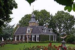 Allinga State Mansion | |||
| |||
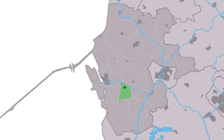 Location in the former Wûnseradiel municipality | |||
 Allingawier Location in the Netherlands | |||
| Coordinates: Coordinates: 53°2′51″N 5°26′45″E / 53.04750°N 5.44583°E | |||
| Country |
| ||
| Province |
| ||
| Municipality |
| ||
| Population (2017) | |||
| • Total | 80 | ||
| Time zone | UTC+1 (CET) | ||
| • Summer (DST) | UTC+2 (CEST) | ||
| Postal code | 8758 | ||
| Telephone area | 0515 | ||


Allingawier is a small village in Súdwest-Fryslân municipality in the Dutch province of Friesland. It is located about 7 km southwest of the city of Bolsward.
Allingawier is a terp village, on an artificial dwelling mound. It had a population of around 80 in January 2017.[1]
History
Before 2011, the village was part of the Wûnseradiel municipality.
References
- ↑ Kerncijfers wijken en buurten 2017 - CBS Statline
| Wikimedia Commons has media related to Allingawier. |
This article is issued from
Wikipedia.
The text is licensed under Creative Commons - Attribution - Sharealike.
Additional terms may apply for the media files.